마지막 빙하기 동안의 남극 캠벨 빙하 축소 기록

초록
남극 테라노바만의 캠벨 빙하 축소 양상을 중심으로, 복수 핵종의 우주선유발 동위원소(in-situ 10Be, in-situ 26Al)를 활용한 빙하지형의 표면 노출 연대 분석을 통해 신생대 제4기 후반 동안의 빙하 거동 변화를 복원하였다. 기존 연구를 통해 장보고 과학기지 배후 산지의 하부 모레인에서 확인한 MIS 3~1 시기의 연대는 10Be만을 이용한 겉보기 노출 연대로 실제 빙하 두께 변화를 해석하는데 제한이 있었다. 본 연구에서 분석한 곤드와나 기지 배후 산지 기반암의 MIS 3 (49.8~35.3 ka) 단순 노출 연대는 빙하 거동 변화를 보다 상세히 밝혀냈다. 이를 바탕으로 마지막 최대 빙하기는 일반적으로 알려진 MIS 2 시기보다 앞선 MIS 4 시기에 나타나 국지적 마지막 최대 빙하기가 발생하였으며, 마지막 빙기동안 빙하의 정체가 아닌 두께 감소가 일어났음을 밝혀내었다. 이러한 결과는 캠벨 빙하의 변동이 기후·해양과 같은 거시적 요인뿐만 아니라, 빙하-화산 상호작용과 같은 지금까지 과소평가된 국지적 요인의 영향을 크게 받았음을 보여주며, 미래의 빙하 융해 및 해수면 상승 예측 모델의 정밀도를 높이기 위해 국지적 환경 조건에 대한 고려가 필수적임을 시사한다.
Abstract
This study focuses on the ice loss patterns of the Campbell Glacier in Terra Nova Bay, Antarctica, and reconstructs glacial dynamics during the Late Quaternary through surface exposure dating using multiple cosmogenic nuclides (in-situ 10Be and in-situ 26Al). Although previously analyzed exposure ages from the lower moraines behind the Jang Bogo Station, based solely on 10Be, had limitations in reconstructing glacier thickness changes, this study provides more definitive insights into glacial behavior through simple exposure ages (49.8~35.3 ka) from bedrock behind the Gondwana Station, corresponding to MIS 3. These findings suggest that the Local Last Glacial Maximum (LLGM) occurred earlier, during MIS 4 rather than the traditionally identified MIS 2, and that there was significant glacier retreat rather than stagnation through the Last Glacial Period. The results highlight that the variations in the Campbell Glacier were strongly influenced not only by broad-scale factors such as climate and ocean conditions but also by previously underestimated local factors, such as glaciovolcanic interactions, and they underscore the necessity of incorporating local environmental conditions into future models predicting accelerated ice melt and sea-level rise.
Keywords:
cosmogenic nuclides surface exposure dating, multiple isotope analysis, local last glacial maximum, glaciovolcanic process, Antarctic ice sheet키워드:
우주선유발 동위원소 노출연대측정, 다핵종 분석, 국지적 마지막 최대 빙하기, 빙하-화산 상호작용, 남극 빙상1. 서 론
지구의 기후 변화, 빙하 질량 변화, 해수면 상승을 예측하기 위한 수치 모델링 연구들은 과거 빙하 규모 변화에 대한 정량적이고 신뢰성 있는 이해를 기반으로 해야 한다. 많은 예측 모델은 ‘한랭한 빙기 = 빙하 성장’, ‘온난한 간빙기 = 빙하 후퇴’와 같은 단순한 상관관계를 전제로 시나리오를 구축해왔으나, 이는 실제 빙하의 반응과 불일치하는 결과를 초래할 가능성이 매우 커 모델링의 정확도와 신뢰도를 저하시킬 수 있다(Robinson and Dowsett, 2010). 이를 해결하기 위해 해양퇴적물 코어나 빙하 코어에서 획득하는 여러 지시자를 지역적으로 분석하여 고기후 및 고환경을 복원하려는 연구들이 수행되어 왔으나, 여전히 확보된 정보가 매우 제한적이다. 특히 빙하의 직접적인 규모 변화는 빙하 코어와 같은 집적대에서는 성장 기록만을 확인할 수 있으며, 해양퇴적물의 경우 공간적인 제한으로 인해 과거 해양으로 전진했던 빙상·빙붕의 수평적인 후퇴 기록만을 복원할 수 있다.
따라서 빙하의 수직적인 두께 변화나 3차원적인 부피를 정량적으로 복원하기 위해 육상 빙하지형을 구성하는 암석 표면에서의 우주선유발 동위원소를 활용한 노출 연대측정이 중요한 대안으로 사용된다(Lal, 1991; Balco et al., 2008). 근래에 발달한 우주선유발 동위원소의 추출 기술과 분석 분해능은 동위원소를 측정, 계산하는데 보다 오차를 감소시켰으며, 보정 시료와 보정 방법들의 발전을 통해 더 정확한 노출연대 계산이 가능해지고 있다(Lifton et al., 2014). 게다가 복수 핵종의 우주선유발 동위원소의 동시 추출, 비교를 통해 밝혀내는 “단순 노출 연대” 판별 기법은 가장 최근의 빙하 후퇴 시기를 명확히 판별하는데 중요한 단서를 제공하고 있다.
남극 대륙은 막대한 빙권의 존재로 인해 전 지구적 해수면 변화에 가장 큰 영향을 미칠 우려가 있는 지역이며, 기후변화에 매우 민감하고 빠르게 반응하며 전지구적 상호작용을 유발하고 있어 고환경 변화의 연구가 집중적으로 이루어지는 지역 중 하나이다. 서남극빙상(West Antarctic Ice Sheet, WAIS)은 두께가 상대적으로 얇고 빙상의 기저가 대부분 해수면보다 높은 고도에 위치하여 해수면 상승과의 상호작용 민감도가 매우 크다(Bamber et al., 2009). 게다가 서남극빙상 하부에는 수많은 활화산이 분포하고 있으며, 이들 화산의 지열은 현재도 빙하의 규모 및 질량의 감소를 유도하고 있다(de Vries et al., 2018). 더 나아가, 빙하 질량 감소에 따른 지각 반응은 오히려 화산 활동을 가속화시켜 다시 빙하 축소를 촉진하는 양의 피드백 메커니즘을 유발할 수 있어, 향후 해수면 변화에 큰 영향을 미칠 위험 요소로 주목된다(Yao and Wortmann, 2022).
반면, 동남극 대륙은 두꺼운 빙상에 덮여 있어 화산 활동의 흔적이 외부에 드러나는 경우가 드물고, 이로 인한 빙하 축소 사례도 매우 제한적으로 보고되어 왔다. 그러나 최근 동남극빙상(East Antarctic Ice Sheet, EAIS)의 말단부 지역, 특히 빙하 후퇴로 노출된 빅토리아 랜드(Victoria Land) 지역 일대에서는 화산 활동과 빙하 변화 사이의 상호작용을 보여주는 지질학적 증거들이 확인되고 있다(Smellie et al., 2018; Rhee, 2023a; Rhee et al., 2025). 본 연구는 동남극에서의 과거 빙하-화산 상호작용을 추적하고, 이로부터 유도된 인과관계 및 상관관계를 밝힘으로써 향후 서남극빙상에서도 발생할 수 있는 유사한 상호작용을 예측하는 데 중요한 기초자료를 제공한다. 특히 캠벨 빙하의 빙하지형에서 확인된 단순 노출 연대(simple exposure age or constant exposure age) 결과는 보다 정확하고 정밀한 빙하의 두께 감소 및 축소 기록을 제공하며, 이를 바탕으로 멜버른 화산의 국지적인 화산 활동이 기후 패턴과 무관하게 빙하의 급속한 후퇴를 유도할 수 있음을 보여주는 중요한 사례가 될 것으로 기대된다.
2. 연구 지역
동남극빙상은 지구상에서 가장 거대한 빙상으로, 약 34 Ma에 처음 형성된 이후 반복적인 성장과 축소 과정을 거치며 유지되어 왔다(그림 1a; Strand et al., 2003; Denton and Sugden, 2005; Baroni et al., 2005). 동남극빙상의 주요 돔 중 찰리(Charlie), 탈로스(Talos), 테일러(Taylor) 돔은 빅토리아 랜드 지역을 향해 흐르며 빙상 유역을 형성하고 있으며, 남극횡단산맥(Transantarctic Mountains)을 넘어 서로스해(Southern Ross Sea)로 유출되고 있다(그림 1b). 마지막 최대 빙하기(Last Glacial Maximum, LGM) 동안 동남극빙상은 현재보다 훨씬 두껍게 성장하고 멀리 전진하여 서남극빙상과 합류하였으며, 로스 대륙붕(Ross Continental Shelf)의 대부분을 뒤덮는 빙상과 로스 빙붕(Ross Ice Shelf, RIS)을 형성하였다(Halberstadt et al., 2016). 이후 홀로세에 접어들며 급격한 붕괴와 후퇴가 진행되었고, 이로 인해 현재와 같은 개방된 로스해가 형성되었다(Lowry et al., 2019; Prothro et al., 2020; Rhee et al., 2020).
현재 서로스해 중심부에 위치한 테라노바만(Terra Nova Bay, TNB)에는 동남극빙상에서 가장 큰 규모로 유출되는 분출빙하들이 흘러나오고 있다(그림 1c). 이들은 크게 세 그룹으로 구분할 수 있다: 1. 서쪽에서 흘러 들어오는 가장 큰 규모의 데이빗 빙하(David Glacier), 2. 북서쪽에서 유입되는 프리슬리(Priestley)와 리브(Reeves) 빙하가 합류한 난센 빙붕(Nansen Ice Shelf), 3. 북쪽에서 흘러나오는 캠벨(Campbell) 빙하 및 이와 맞닿아 있는 멜버른 화산체의 국지적 소규모 산록 빙하들(Mt. Melbourne piedmont glaciers). 멜버른 화산체 주변의 빙하는 과거 캠벨 빙하가 더 두껍게 성장했을 당시에는 하나의 빙체를 이루었을 것으로 추정된다(Rhee, 2023c).

Satellite image map based on the Landsat Image Mosaic of Antarctica (LIMA), showing: (a) Antarctica and the surrounding Southern Ocean, (b) the East Antarctic Ice Sheet (EAIS), extending over Victoria Land and flowing into the western Ross Sea, and (c) the Terra Nova Bay region (RIS: Ross Ice Shelf, WAIS: West Antarctic Ice Sheet) (Bindschadler et al., 2008).
현재의 캠벨 빙하는 북빅토리아 랜드(Northern Victoria Land)의 산악 지대 사이에 발달한 계곡을 따라 흐르며, 브라우닝 산(Mt. Browning)과 멜버른 화산체(Mt. Melbourne volcano) 사이를 지나 테라노바만으로 유출되고 있다. 브라우닝 산 일대에는 일부 기반암이 노출된 봉우리들을 제외하고, 대부분 지역에서 빙하에 의해 운반된 물질이 퇴적되어 형성된 모레인 지형이 분포한다(Baroni et al., 2005; Di Nicola et al., 2009; Rhee et al., 2019). 한국의 장보고 과학기지 배후에 위치한 모레인 지역은 ‘장보고 구릉지(Jangbogo Hills)’로, 독일 곤드와나 기지 배후의 기반암 노출지인 안테나 봉우리(Antenna Peak) 및 인접한 모레인 지역은 ‘곤드와나 구릉지(Gondwana Hills)’로 명명하였다. 이 구릉지는 주로 화강암, 화강편마암, 반상 화강암의 쇄설물들로 구성되어 있으며, 이는 캠벨 빙하 상류의 기반암에서 침식되어 운반된 것으로 보인다(Di Nicola et al., 2009; Rhee et al., 2019).
한편, 캠벨 빙하 반대편에 위치한 멜버른 화산은 플라이오세부터 플라이스토세에 걸쳐 여러 차례 분출하며 형성된 복합 화산으로, 주로 현무암과 유문암으로 구성되어 있다(Giordano et al., 2012; Smellie et al., 2023). 테라노바만의 가장 외곽에 위치한 케이프 워싱턴(Cape Washington) 지역은 약 4.1~1.7 Ma에 걸쳐 분출, 형성되었으며, 캠벨 빙하에 가장 가까이 인접한 쉴드 누나탁(Shield Nunatak)은 약 1.6~0.06 Ma에 분출된 분석구나 응회구가 나타난다. 또한, 멜버른 화산체에서는 플라이스토세 중반인 약 400 ka에 대규모 분출이 발생하여 주요 사면이 형성되었으며, 약 123.6~90.7 ka에 화산체가, 그리고 50.0~35.1 ka에는 정상부가 각각의 분출에 의해 형성된 것으로 나타났다. 특히 멜버른 화산체의 북부에 위치한 해로우 피크(Harrows Peak)에서는 빙하 하부에서 발생한 용암 분출을 지시하는 구조적 및 암석학적 증거가 확인되었으며(Smellie et al., 2018), 캠벨 빙하의 모레인에 뒤섞여 발견되는 화산암과 화강암류의 10Be 겉보기 노출 연대 분석 결과를 통해 캠벨 빙하 말단부에서 멜버른 화산과의 빙하화산 상호작용 가능성이 제기되었다(Rhee et al., 2025).
3. 연구 방법
3.1. 다핵종 우주선유발 동위원소를 이용한 노출연대측정 원리
초신성 폭발이나 태양 활동 등에서 방출된 고에너지 방사선인 우주선(cosmic ray)은 지구 대기로 유입되며, 다양한 원소들과 충돌하여 핵반응을 일으킴으로써 우주선유발 동위원소(cosmogenic nuclides)를 생성한다. 이들 동위원소는 생성 위치에 따라 두 가지 유형으로 구분된다. 첫째, 대기 중의 원소들과의 상호작용을 통해 생성되어 강수와 함께 지표로 침전되는 “meteoric” 성분은 호수, 하천, 해양 퇴적물 등 환경 변화 연구에 활용된다. 둘째, 지표까지 도달하면서 다소 약화된 우주선이 노출된 암석 내 특정 광물과 반응하여 생성되는 “in-situ” 성분은 암석의 노출 연대, 퇴적 및 매몰 시기, 유역 분지의 삭박률 측정 등에 사용된다(Lal, 1991).
빙하의 전진 및 성장으로 인해 빙하 기저의 기반암이나 빙하 운반 물질이 매몰되면, 이들은 우주선과 상호작용하지 못하게 된다(그림 2a). 반대로 빙하가 후퇴하거나 두께가 감소되면서 암석이 지표에 노출되면, 노출된 암석 내 원소들은 우주선과의 핵반응을 통해 우주선유발 동위원소를 생성하기 시작한다. 이때 불안정 동위원소는 생성과 동시에 반감기에 따른 붕괴가 일어나므로, 노출 시간이 길어질수록 축적된 농도는 생성량과 붕괴량의 함수로 결정된다(그림 2b). 따라서 암석 표면에서 추출한 특정 동위원소의 농도를 측정하면, 해당 위치의 암석이 지표에 노출된 시점, 예를 들어 빙하가 사라진 시점을 연대로 환산할 수 있게 된다(Lal, 1991; Balco et al., 2008).

(a) Simplified schematic illustrating glacial thinning and the subsequent exposure of glacial bedrock or glacially transport ederratics. Once exposed, these ice-free surfaces begin to accumulate cosmogenic nuclides produced by interactions between incoming cosmic rays and minerals in the rock. (b) Continuous exposure results in the steady accumulation of cosmogenic nuclides, while their concentrations are simultaneously reduced through radioactive decay, according to each nuclide's half-life. Because the true timing of the most recent exposure cannot be determined using only a single nuclide, the resulting age estimate is referred to as the “apparent exposure age.” A statistically significant number of samples, collected independently from nearby locations and similar elevations, is required for reliable interpretation of exposure ages.
우리가 추출하고 측정한 우주선유발 동위원소의 농도는, 해당 암석이 노출되어 있던 기간 동안의 동위원소 생성과 붕괴가 누적된 결과를 반영한다. 따라서 이 수치만으로 암석이 언제부터 노출되었는지를 분명히 판단하기는 어렵다. 예를 들어, (1) 암석이 과거에 한 차례 노출되었다가, (2) 다시 밀도가 높은 물질(암석, 빙하 등)에 매몰된 후, (3) 다시 노출되는 경우를 생각할 수 있다(그림 3a). 각 과정에서 동위원소는 (1) 생성과 붕괴가 이루어지다가, (2) 생성은 일시적으로 중단이 되고 붕괴만 진행이 되며, (3) 이전의 잔여량(inheritance)을 포함한 상태에서 추가적으로 생성과 붕괴가 진행된다(그림 3b). 따라서 여러 이벤트를 거쳐 누적된 동위원소의 농도는 실제 노출 시기보다 더 오래된 결과로 나타날 수 있으며, 단일 동위원소만을 이용한 연대측정은 ‘겉보기 노출 연대’로 간주한다(Heyman et al., 2011). 이런 한계를 보완하기 위해, 인근 지역에서 복수의 시료를 채취하여 비교하고, 통계적 분석을 통해 일관된 경향성을 도출하는 방식이 활용된다.

(a) Simplified schematic illustrating glacial thinning and subsequent readvance, showing the exposure of glacial bedrock or erratics and their potential reburial due to ice re-coverage. The residual concentration of nuclides is referred to as "inheritance," leading to an overestimation of the concentration and exposure age compared to the actual most recent exposure event. (b) Using multiple cosmogenic nuclides with different production rates (atoms per year) and distinct decay half-lives reveals the occurrence of multiple exposure events. A nuclide with a shorter half-life experiences a greater decrease in concentration during the burial period, as no further nuclear interactions or production occur, resulting in a lower isotopic ratio compared to cases of simple exposure. These lower isotopic ratios appear in the lower range of the "simple exposure island" on the diagram.
보다 신뢰도 높은 노출 연대를 확인하기 위해서는 서로 다른 생성률과 붕괴율을 가진 두 개 이상의 핵종을 분석하는 다핵종 분석 방법(multiple isotope analysis)이 활용된다(그림 3b). 만약 시료가 지속적이고 단일한 노출만을 경험했다면, 각 동위원소는 생성률과 반감기에 따라 시간에 비례한 농도 변화를 보이게 된다. 이 경우, 동위원소 간의 농도 비율이 일정한 범위 내에서 유지되며, 이를 단순 노출 연대로 해석할 수 있다. 반면, 시료가 매몰, 이동, 침식 등의 영향을 받아 노출 환경에 변화가 발생했을 경우, 반감기가 상대적으로 짧은 동위원소의 농도가 불균형적으로 감소하게 된다. 이로 인해 핵종 간 농도 비율이 일정 범위를 벗어나게 되며, 이러한 경우를 복합 노출 연대(multiple exposure age)로 구분할 수 있다(Lal, 1991; Gosse and Phillips, 2001).
3.2. 현장 조사 및 시료 처리
2021년 남극 장보고 과학기지 하계 연구대 활동을 통해 캠벨 빙하 지역의 모레인 및 빙하 기저 기반암이 노출된 지역에 대한 현장 탐사를 수행하였다. 기반암이 노출된 안테나 봉우리 동측 및 서측 사면에서 각각 2개씩, 북측 사면에서 1개의 암석 표면 시료를 채취하였다(그림 4a). 암석이 노출된 이후 눈에 의해 매몰되거나 표면 침식으로 인한 교란 가능성을 방지하기 위해, 강설 기록과 암석 표면의 찰흔(striation) 존재 여부를 확인하여 암석의 노출 이후 보존 상태가 양호함을 판단하였다(Fabel and Harbor, 1999; Di Nicola et al., 2009; Rhee et al., 2019).

(a) An aerial photograph of the study area, with a white dashed line indicating the longitudinal profile along Gondwana Hills where glacial moraines and erratics are distributed. The white ellipsoid indicates the sampling area, Antenna Peak, where bedrock is exposed. (b) 10Be exposure ages and result of the multiple isotopes analysis (in-situ 10Be and 26Al). Blue bold numbers (with blue dots and 1σ error ellipses in the diagram) represent simple exposure ages, while the red regular number (with a red dot and ellipse) indicates an apparent exposure age that may reflect multiple exposure events or a substantial surface erosion of the outcrop.
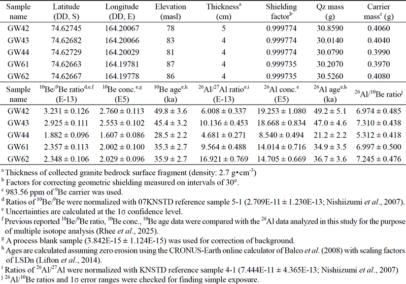
채취한 시료는 분쇄 과정을 거친 후, 고려대학교 우주선유발 동위원소 실험실의 표준 작업 절차에 따라 모래 크기의 순수 석영 입자를 분리하였다(Kim et al., 2024). 이후 일련의 화학 처리를 통해 베릴륨(Be) 및 알루미늄(Al)을 선별적으로 추출, 최종적으로 산화물로 만들었으며, Nb 및 Ag와 같은 전도성 물질과 혼합하여 타겟(target bullet) 형태로 압축하였다. 각 시료의 동위원소 비율(10Be/9Be 및 26Al/27Al)은 한국과학기술연구원(KIST)의 질량가속기(Accelerator Mass Spectrometer, AMS)를 이용해 측정하였고, 인위적으로 주입한 9Be와 시료 내에서 추출된 27Al 농도를 바탕으로 각 저준위 동위원소의 농도를 계산하였다. 27Al 농도는 한국기초과학지원연구원(KBSI)의 유도결합플라즈마 원자방출분광기 (Inductively Coupled Plasma-Atomic Emission Spectrometer, ICP-AES)를 이용하여 분석하였다. 최종적으로 산출된 방사성 동위원소 간 비율(26Al/10Be)을 통해, 빙하 후퇴 또는 두께 감소 이후 안정적이고 지속적으로 노출된 시료를 판별하였으며, 이를 “단순 노출 연대”로 해석하였다.
4. 결 과
우주선유발 동위원소 in-situ 10Be 노출 연대는 동쪽 사면에서 각각 49.8 ± 3.6 ka (GW42, 78 masl)과 45.4 ± 3.2 ka (GW43, 83 masl), 서쪽 사면에서 35.9 ± 2.7 ka (GW61, 87 masl)과 35.3 ± 2.7 ka (GW62, 86 masl)로 나타났다(그림 4b; 표 1). 이에 상응하는 in-situ 26Al 노출 연대는 각각 49.2 ± 5.1 ka과 47.0 ± 4.6 ka, 36.7 ± 3.6 ka과 34.9 ± 3.5 ka로, 10Be 노출 연대와 비교하여 유의미한 차이를 보이지 않았다. 또한, 이 4개 시료에 대해 핵종간 동위원소비(26Al/10Be)를 분석한 결과, 해당 비율과 오차 범위는 7.3 ± 0.4에서 6.9 ± 0.4사이로 나타났으며, 이는 단순 노출을 지시하는 영역에 수렴하는 것으로 확인되었다.

Result of 10Be and 26Al analysis and exposure age dating.
봉우리의 북사면에서 채취한 한 시료(GW44, 81 masl)의 경우, 10Be 노출연대는 28.5 ± 2.2 ka, 26Al 노출연대는 21.2 ± 2.2 ka로 측정되어 전체 시료 중 가장 최근의 노출연대를 보였다. 하지만 두 핵종 간 노출연대를 비교할 경우 약 7.3 ka의 차이가 나타났으며, 핵종 간 비율(26Al/10Be) 역시 5.3 ± 0.4로 단순 노출의 범위보다 유의하게 감소된 결과가 나타났다. 이는 암석 표면의 손실이나 단기간 매몰에 의해 반감기가 더 짧은 26Al가 상대적으로 감소된 결과로 해석된다. 이를 바탕으로, 동쪽 사면의 49.8 ± 3.6 ka과 45.4 ± 3.2 ka, 서쪽 사면의 35.9 ± 2.7 ka과 35.3 ± 2.7 ka은 각 사면의 최근 노출 시기, 즉 빙하가 사라진 시기를 반영하는 ‘단순 노출 연대’로 해석된다. 반면, 북쪽 사면의 28.5 ± 2.2 ka은 복합적인 노출-매몰 이력을 반영하는 ‘겉보기 노출 연대’로 간주되어, 실제 노출 시기의 추정에는 한계가 있는 것으로 판단된다.
5. 논 의
5.1. 신생대 제4기 후반에 걸친 일관적인 빙하 두께 감소 기록
마지막 최대 빙하기(Last Glacial Maximum, LGM)는 마지막 빙기(Last Glacial Period; Marine Isotope Stage, MIS 4~2) 동안 빙하가 가장 두껍고 가장 넓게 확장된 시기로 정의되며, 일반적으로 MIS 2 기간 중 약 26.5~19 ka 로 알려져 있다(Clark et al., 2009). 남극에서의 실제 LGM 시기와 범위를 밝혀내기 위해, 동남극빙상의 말단부에 위치한 분출 빙하 주변의 빙하지형을 대상으로 한 우주선유발 동위원소 노출 연대 측정을 활용한 많은 연구들이 시도되었다(Jones et al., 2015; Goehring et al., 2019; Rhee et al., 2020; Stutz et al., 2021). 하지만 대부분의 연구들은 MIS 2 이후 시기의 빙하 후퇴 및 감소에 관한 기록만을 확인하는 데 그쳤으며, LGM 시기의 빙하 확장 범위 및 그 이전의 빙하 변화에 대한 구체적인 증거는 거의 확인되지 않았다.
특히 마지막 빙기를 관통하는 동안의 빙하 두께 및 면적 변화에 대한 구체적인 복원 연구들은 매우 제한적이었기에, 대부분의 연구는 마지막 빙기 동안의 전반적 기온 하강에 따라 빙하가 점진적으로 확장되고 두꺼워졌을 것이라 가정하고 있다. 이로 인해 LGM이라는 개념은 종종 마지막 빙기 중 “빙하가 가장 확장된 시기”보다는 “기온이 가장 한랭했던 시기”로 간주되며, 실제로 많은 미래 예측 모델링 연구들은 “한랭한 빙기=빙하의 성장”, “온난한 간빙기=빙하의 감소”라는 전제를 기반으로 수행되고 있다. 하지만 이러한 가정은 실제 빙하의 물리적 규모와 기온 변화 사이의 실제 관계와 일치하지 않을 수 있으며, 이 둘을 단순한 선형적 관계로 이해하는 것은 매우 위험하다. 따라서 과거 빙하 규모 변화를 복원하는 데 있어, LGM 이후의 빙하 축소를 밝히는 것도 중요하지만, 더 나아가 단기적으로는 LGM 시기의 정확한 시점과 빙하 규모 변화를, 장기적으로는 반복되는 빙기와 간빙기 동안 실제로 발생한 빙하 감소의 양상과 그 기작을 규명하는 것이 모델링 연구의 정밀도를 높이는 데 필수적이다.
히말라야와 안데스 지역의 연구들은 MIS 2를 기준으로, 이전 또는 이후 시기에 빙하가 더 두껍거나 더 넓게 확장된 빙하의 증거를 발견함으로써, 국지적 마지막 최대 빙하기(Local Last Glacial Maximum, LLGM)의 중요성을 알렸다(Owen et al., 2002; Smith et al., 2005). 동남극빙상 내륙 지역에서도 MIS 3의 약 50 ka에 단순 노출 연대가 모레인에서 발견되어 LLGM이 그 이전 시기에 발생했음을 보여주었으며, 남빅토리아 랜드의 드라이 밸리에서도 MIS 3의 51~26 ka에, 북빅토리아 랜드의 테라노바만 지역에서도 MIS 4와 3에 걸친 65~33 ka에 단순 노출 연대들이 발견되었다(Lilly et al., 2010; Joy et al., 2017; Rhee et al., 2019, 2022a). 이러한 MIS 2보다 앞선 단순 노출 연대의 증거들은, 마지막 빙기 동안 MIS 2보다 이전의 시기에 더 두꺼운 빙하가 존재하였음을 보여준다. 특히 MIS 4 및 3의 시기에는 빙하의 두께가 감소되며 빙하 지형의 노출이 일어났고, 일반적으로 LGM이라고 알려진 MIS 2 시기에는 이러한 노출 지역을 다시 뒤덮지 못하고 노출이 지속되어버린, 즉 실질적인 빙하 성장이 없었음을 시사한다.
캠벨 빙하의 장보고 구릉지 모레인을 대상으로 한 이전 연구에서는 구릉지 상부의 3개 모레인에서 연속적으로 MIS 5 중반에 걸친 단순 노출 연대들(10Be & 26Al)이 확인되었으며, 하부의 모레인 중 하나에서는 동일한 고도(~90 masl)에서 MIS 3~2에 해당하는 겉보기 노출 연대(10Be)들이 혼재되어 나타났다(Rhee et al., 2019). MIS 3의 겉보기 노출 연대를 통해 MIS 4 시기에 더 두꺼운 빙하가 존재(LLGM)하였음을 추정하였고, 혼재된 MIS 2의 노출 연대를 통해 ‘MIS 3~2의 기간 동안 해당 고도에서 빙하가 정체(stagnation)되어 있었다’ 해석하였다(그림 5a). 겉보기 노출 연대가 혼재하는 경우, 통계적 확률 밀도 분석을 통해 더 가능성이 높은 연대를 채택하여 해석하지만, 각각 4개와 3개의 시료가 쌍봉 형태로 나타나 두 시기에 걸쳐 빙하가 거의 정체되었고 시간차를 두고 노출되었다 판단하였다.

(a) Previous study showing glacial lowering stages of the Campbell Glacier since MIS 5 in Jangbogo Hills (JBG) (Rhee et al., 2019). A simple exposure age from the late MIS 5 led to independently formed clusters of apparent exposure ages at ~90 masl, on late MIS 3 and late MIS 2. It was interpreted to have experienced a Local Last Glacial Maximum (LLGM) between early MIS 4 and late MIS 3, followed by a period of stagnation from late MIS 3 to late MIS 2, which corresponds to the globally recognized Last Glacial Maximum (LGM). (b) Our newly analyzed simple exposure ages from the Gondwana Hills (GWH) through MIS 3 not only support continuous glacial lowering throughout the entire Last Glacial Period (MIS 4-2), rather than glacial stagnation, but also constrain the spatiotemporal extent of both the LLGM and LGM.
곤드와나 구릉지의 기반암 노출지인 안테나 봉우리는 장보고 구릉지의 MIS 3~2 겉보기 노출 연대가 혼재되어 나온 하부 모레인과 유사한 고도에 위치한다(87~78 masl). 이 봉우리 역시 사면별로 차이가 나타나는 겉보기 노출 연대들(49.8~28.5 ka)이 MIS 3~2에 걸쳐 나타남으로써, 마지막 빙기 동안 정체되어 있던 빙하가 시간차를 두고 두께가 감소되며 노출된 것으로 해석되었다(Rhee et al., 2025). 하지만 본 연구에서는 동일한 기반암 시료에 대해 10Be과 26Al 복수 핵종을 분석함으로써, 49.8~35.3 ka (n=4)의 MIS 3에 걸친 연대들이 모두 단순 노출 연대임을 규명하였다(그림 5b). 단순 노출 연대는 빙하 지형의 노출 후 재매몰없이 지속적으로 노출되었음을 의미하므로, 이는 빙하가 후퇴한 이후 다시 두꺼워져 해당 지형을 덮을 만큼 성장하지 못했음을 명확히 보여준다. 따라서, 캠벨 빙하는 마지막 빙기 초기인 MIS 4 시기에 기반암 봉우리를 완전히 덮고 있었으며, 이후 MIS 3 동안 동·서 사면 모두에서 빙하가 후퇴하면서 기반암이 노출되었다(그림 6). 이러한 MIS 3 단순 노출 연대는 장보고 구릉지 모레인에서 MIS 3 겉보기 노출 연대로 추정되었던 MIS 4의 LLGM의 가능성을 보다 분명하게 뒷받침한다. 이러한 노출 상태는 전지구적 LGM으로 알려진 MIS 2 기간에도 유지되었다. 이는 LGM 시기에도 해당 고도까지 빙하가 도달하지 못했음을 의미하며, 마지막 빙기 동안 빙하가 지속적으로 감소하였음을 보여준다. 마찬가지로, 장보고 구릉지 모레인의 혼재되어 있던 MIS 2의 겉보기 노출 연대는, 곤드와나 구릉지의 MIS 2 겉보기 노출 연대와 함께 교란되었을 가능이 높아 해석에서 제외되었으며, MIS 2 기간에는 빙하가 정체된 것이 아닌 오히려 두께가 지속적으로 감소하였음을 알 수 있다.

Satellite image of the study area and the Campbell Ice Tongue, showing compiled 10Be exposure ages of glacially transport ederratics and subglacial bedrock (simple exposure ages in bold and apparent exposure ages in regular font), along with glacial extent limits for each MIS, indicated by blue dashed lines. Based on our newly analyzed simply exposed bedrock dated to 49.8~35.3 ka (MIS 3), we propose a more detailed constraint on glacial dynamics throughout the Last Glacial Period (yellow dashed lines).
종합적으로 캠벨 빙하는 신생대 제4기 후반 MIS 6 이후로 지속적인 두께 감소 추세를 보여왔다(그림 7). 빙기와 간빙기가 반복되었음에도 불구하고, 캠벨 빙하는 간빙기에는 증가한 속도로, 빙기에는 감소된 속도로 두께가 감소했으며, 각 최대 빙기 동안의 최대 고도는 MIS 6 (Penultimate Glacial Maximum, PGM) > MIS 4 (LLGM) > MIS 2 (LGM)의 순서로 각각 630 masl 이상, 150~90 masl , 78~41 masl의 고도 범위에서 나타났다. 이러한 장기적인 빙하 축소 경향은 테라노바만으로 유출되는 데이빗 빙하에서도 동일하게 관측되었으며, 해당 지역의 모레인의 단순 노출 연대는 MIS 7 (234.2 ± 13.1 ka, 545 m)과 MIS 4 (64.8 ± 13.7 ka, 222 m)에서 확인되었다(Rhee et al., 2022a). 이러한 증거들은 빙하의 두께와 범위 변화가 밀란코비치 주기(Milankovitch Cycle)와 같은 전 지구적 기후 요인에만 영향을 받는 것이 아니라, 해당 지역의 지형, 해양, 강설량 등 복합적인 지역적 환경 요인의 영향을 크게 받았음을 보여준다.

Glacial lowering stages in the terminal area of the Campbell Glacier during the late Quaternary (Rhee et al., 2019, 2025; Rhee, 2023a; this study). Bold and regular fonts indicate simple and apparent exposure ages, respectively.
5.2. 일방적인 빙하 두께 감소 추세를 유발한 기작
일반적으로 ‘빙기에는 빙하 성장’, ‘간빙기에는 빙하 감소’라는 단순화된 온도-빙하 상관관계가 널리 받아들여져 왔으며, 이러한 인식은 주로 빙하의 집적대에서 채취한 빙하 코어의 적설 기록이나, 소모대 말단부에서 관측된 빙하의 전진 및 후퇴 양상을 근거로 하고 있다. 그러나 캠벨 빙하의 경우, 이러한 온도 중심의 일반적인 경향과는 다른 예외적 반응이 관찰된다. 간빙기 동안에는 강설량과 빙하의 성장이 증가하였음에도 불구하고, 상승한 기온이 이를 압도하여 빙하의 급격한 후퇴 및 감소가 발생한 것으로 보인다(그림 8a; Rhee et al., 2019). 반면, 빙기 동안에는 낮은 기온이 빙하의 성장에 유리한 조건을 제공하였음에도 불구하고, 극도로 건조한 기후로 인해 강설량이 현저히 감소하면서 실질적인 빙하 성장은 제한되었다. 특히 마지막 빙기에는 빙상과 빙붕이 로스 대륙붕의 대부분 지역을 덮고 있었기 때문에 해양 수증기의 유입이 차단되었고, 이로 인해 강설량이 더욱 극단적으로 제한되었던 것으로 해석된다.

(a) Glacial lowering stages with exposure ages from Jangbogo Hills moraine are compared with climatic change patterns (Rhee et al., 2019). δ18O value and snow accumulation rate are derived from Talos Dome ice core records (Bazin et al., 2013, Vallelonga et al., 2013). (b) Compiled exposure ages, particularly simple exposure ages, are compared with additional factors that may have contributed to glacial lowering. Count of tephra layers are referred from Talos Dome ice core studies, along with the volcanic eruption ages of Mt. Melbourne (Narcisi et al., 2010, 2016; Giordano et al., 2012). The unexpected ice-lowering events coincide with volcanic activities, suggesting a strong likelihood of glaciovolcanic interactions rather than climatic change patterns.
이러한 현상은 홀로세 기후 최적기(Holocene Climate Optimum) 동안 로스해 지역의 빙상 및 빙붕이 테라노바만 내부까지 붕괴되며, 인근 홀링스워스 빙하에서 강설량 증가와 함께 빙하 축소 속도가 급격히 감소했던 사례에서도 확인된다(Rhee et al., 2022b). 이는 수분 공급의 유무가 이 지역의 빙하 질량 변화에 있어 결정적인 역할을 했음을 보여준다. 실제로 캠벨 빙하는 신생대 제4기 동안 반복된 빙기–간빙기 주기에도 불구하고 장기적으로 지속적인 음의 순 질량 수지(net negative mass balance)를 보여주었으며, 이는 전반적인 빙하 두께 감소로 이어졌다. 특히 마지막 빙기에는 수분 공급의 부족으로 인한 성장의 제한을 넘어서 오히려 빙하의 축소가 발생했던 것으로 나타나는데, 이는 단순한 기후 요인을 넘어서는 다양한 지역적 요인이 추가적으로 복합적으로 작용한 결과로 해석된다.
기후 요인 외에도, 빙하의 후퇴에는 단기적이면서도 지역적인 요인들이 복합적으로 작용한 기록들이 보고되었다. 대표적인 요인으로는 빙하 기저 지형의 형태와 해양과의 상호작용으로 인해 발생하는 해양-빙상 불안정성(Marine Ice Sheet Instability)이 있다(Jones et al., 2015; Goehring et al., 2019; Rhee et al., 2020; Stutz et al., 2021; Rhee, 2023b). 빙하 기저 지형이 역방향으로 경사진 경우(내륙으로 갈수록 깊어지는 지형), 빙하 접지선(grounding line)이 후퇴하면서 지지력이 점차 약화된다. 이때 접지선의 후퇴 위치에서는 더 두껍고 질량이 큰 빙상을 지탱해야 하기 때문에, 빙상의 불안정성이 더욱 증폭될 수 있다(Gomez et al., 2010; Jamieson et al., 2012). 더불어, 온난한 남극 순환 심층수(Circumpolar Deep Water, CDW)가 빙하 하부 및 빙하 접지선 영역으로 침투하게 되는데, 빙하 하부의 융해가 가속화되어 빙하의 후퇴를 촉진할 수 있다. 다만, 마지막 빙기 기간에는 테라노바만을 비롯한 로스해 전역이 빙상 및 빙붕으로 뒤덮여 있었으므로, 해양이 빙하의 후퇴 및 축소에 미친 영향은 거의 없었을 것으로 판단된다.
화산 활동 또한 빙하 변화에 영향을 미치는 중요한 지역적 요인 중 하나이다. 화산재의 공급은 국지적인 대기 온도 상승을 유발하고, 빙하 표면의 반사율(albedo) 변화로 인해 태양 복사 에너지 흡수를 증가시켜 빙하 감소를 가속화할 수 있다(Conway et al., 2015; Muschitiello et al., 2017). 더불어, 화산 활동으로 분출된 용암류가 빙하 표면이나 가장자리로 직접 유입되거나, 빙체 기저에 있는 화산의 폭발 및 용암 분출로 인해 차가운 빙하와 뜨거운 용암이 접촉하는 현상이 발생한다. 이러한 빙하-화산 상호작용(glaciovolcanic interaction)은 빙하화산체(glaciovolcanic edifice)를 형성할 뿐만 아니라, 국지적으로 빙하 질량의 급격한 손실을 유발한다(Pedersen and Grosse, 2014; Smellie et al., 2018; Russell et al., 2023). 캠벨 빙하 역시 MIS 5 중반에 발생한 급격한 축소 현상이 멜버른 산의 화산 활동과 직접적으로 연관되었을 가능성이 제기되었으며, 이를 뒷받침하는 지형학적, 지질학적, 연대측정 증거들이 제시되었다(Rhee, 2023a; Rhee et al., 2025).
멜버른 화산은 현재 캠벨 빙하의 말단부와 직접 접촉하고 있으며, 플라이오세 시기부터 분출을 시작하여 플라스토세 후반까지 지속된 화산 활동을 통해 현재의 멜버른 화산체가 형성되었다(Giordano et al., 2012). MIS 5 초기에는 남반구의 일사량과 기온이 가장 높았던 반면, MIS 5 중반부터는 기온이 점차 하강하는 추세였음에도 불구하고 캠벨 빙하의 소모율은 오히려 급격히 증가하였다(그림 8b). 장보고 구릉지 모레인은 캠벨 빙하를 중심으로 볼 때 멜버른 화산의 반대편에 위치하고 있음에도 불구하고, 현무암이나 표면에 용암이 묻은 채 굳은 화강암류의 암석들이 뒤섞여 발견되었다. 또한, 멜버른 화산의 서쪽 사면에서는 빙하와 접한 지역을 중심으로 침식 및 지형 변화가 관찰되며, 용암 대지가 형성된 분출 시기(123.6~90.7 ka)와 빙하가 급격히 소실되며 노출된 모레인의 형성 시기(97.0~90.8 ka)가 유사하게 나타난다. 이는 해당 시기에 캠벨 빙하와 멜버른 화산 간의 빙하-화산 상호작용이 있었음을 보여주었다.
이후, 마지막 빙기에 해당하는 MIS 4~2시기에도 캠벨 빙하의 축소는 지속적으로 진행되었으며, 이는 곤드와나 구릉지 기반암의 단순 노출 연대(49.8~35.3 ka)나 장보고 구릉지 모레인의 겉보기 노출 연대(35.1~30.7 ka)와 같이 MIS 3를 중심으로 나타났다. 이 시기는 멜버른 산의 분화구가 형성되며 분출이 일어나던 시기(50.0~35.1 ka)와 거의 일치하며, 인근 탈로스 돔 빙하 코어에서도 같은 시기인 MIS 3 중반 동안 화산재 층의 급격한 증가가 발견되었다(Narcisi et al., 2010, 2016; Giordano et al., 2012). 따라서 캠벨 빙하의 변화는 장기적 규모에서는 주로 기후 변화에 따라 소모 속도가 조절되었으나, 지역적이고 일시적인 요인들, 특히 빙하-화산 상호작용에 의해 기후 변화와는 역설적인 빙하의 반응이 유도되었을 가능성이 크다. 특히 이러한 패턴은 인근의 프리슬리 빙하나 데이빗 빙하와 같은 분출빙하들과도 상이한 감소 패턴을 보이며, 멜버른 화산에 인접한 캠벨 빙하에만 매우 국지적인 화산의 영향이 작용되었음을 보여준다.
6. 결 론
기존의 캠벨 빙하 모레인 연구는 MIS 5 중반(97.0~90.8 ka, 320~150 masl)의 단순 노출 연대 결과를 통해 MIS 6 시기의 빙하 두께가 MIS 4보다 두꺼웠을 가능성을 제시하였다(Rhee et al., 2019). 그러나 MIS 4 이후의 빙하 변화에 대한 증거는 겉보기 노출 연대에 의존하고 있어 정량적인 재구성이 어려웠다. 본 연구에서는 기반암에서 확보한 MIS 3에 걸친 단순 노출 연대(49.8~35.3 ka, 87~78 masl)를 추가함으로써, 마지막 빙기 전반에 걸친 빙하 두께 감소 양상을 보다 정밀하고 정확하게 재구성할 수 있었다.
그 결과, 신생대 제4기 후반에 걸친 지속적인 빙하 두께 감소가 보다 자세하게 입증되었다. 특히 MIS 4 시기에는 LLGM (150~90 masl)이 나타났고, 이후 MIS 3와 2를 거치며 빙하 감소가 지속되어 MIS 2의 LGM (78~41 masl)에는 더욱 얇아진 빙하 두께가 확인하였다. 이에 따라, 기존의 ‘마지막 빙기동안 한랭한 기후로 인한 빙하 두께의 성장’ 또는 ‘한랭했지만 건조한 환경으로 정체되었던 빙하 두께’와 같은 추정은 본 연구 결과에 따라 ‘마지막 빙기 동안에도 감소한 빙하 두께’와 같이 수정되어야 한다.
더불어 캠벨 빙하는 기후, 해양, 지형과 같이 빙하 질량 변화를 야기하는 여러 요인들의 변화와 비교하였을 때 상이하거나 역설적인 반응이 나타났으며, 이는 매우 국지적이고 일시적인 요인인 화산 활동의 영향을 상대적으로 크게 받았음을 보여준다. 특히 MIS 5 중반(97.0~90.8 ka)과 MIS 3 (49.8~35.3 ka)에 걸쳐 나타난 빙하의 급격한 붕괴 및 두께 감소는 해당 시기의 기온이 오히려 감소하고 있었던 점과 대비되어, 기후 변화와 상반되는 역설적인 반응을 보여준다.
이 시기들은 캠벨 빙하와 인접해 있는 멜버른 화산의 주요 분출 시기(123.6~90.7 ka 및 50.0~35.1 ka)와 빙하 코어에서 화산재 층이 뚜렷하게 증가한 시기와도 일치하며, 이는 빙하–화산 상호작용의 가능성을 강하게 보여준다. 더불어 연대학적 증거뿐만 아니라 빙하화산체의 형태와 모레인의 구성 물질 등과 같은 지형·지질학적 증거 역시 이 같은 상호작용을 뒷받침한다. 이러한 연구 결과는 기후, 해양, 지형 등 기존 중심 요소 외에도, 화산 활동처럼 국지적이고 일시적이지만 영향력이 큰 요인이 빙하 규모 변화에 미치는 영향을 부각시키는 데 중요한 자료로 활용될 것으로 보인다.
Acknowledgments
This work was supported by Korea Polar Research Institute (KOPRI) grant funded by the Ministry of Oceans and Fisheries (KOPRI PE25090).
References
-
Balco, G., Stone, J.O., Lifton, N.A. and Dunai, T.J., 2008, A complete and easily accessible means of calculating surface exposure ages or erosion rates from 10Be and 26Al measurements. Quaternary Geochronology, 3, 174-195.
[https://doi.org/10.1016/j.quageo.2007.12.001]

-
Bamber, J.L., Riva, R.E., Vermeersen, B.L. and LeBrocq, A.M., 2009, Reassessment of the potential sea-level rise from a collapse of the West Antarctic Ice Sheet. Science, 324, 901-903.
[https://doi.org/10.1126/science.1169335]
-
Baroni, C., Noti, V., Ciccacci, S., Righini, G. and Salvatore, M.C., 2005, Fluvial origin of the valley system in northern Victoria Land (Antarctica) from quantitative geomorphic analysis. Geological Society of America Bulletin, 117, 212-228.
[https://doi.org/10.1130/B25529.1]
-
Bazin, L., Landais, A., Lemieux-Dudon, B., Toyé Mahamadou Kele, H., Veres, D., Parrenin, F., Martinerie, P., Ritz, C., Capron, E., Lipenkov, V., Lourte, M.-F., Raynaud, D., Vinther, B., Svensson, A., Rasmussen, S.O., Severi, M., Blunier, T., Leuenberger, M., Fischer, H., Masson-Delmotte, V., Chappellaz, J. and Wolff, E, 2013, An optimized multi-proxy, multi-site Antarctic ice and gas orbital chronology (AICC2012): 120-800 ka. Climate of the Past, 9, 1715-1731.
[https://doi.org/10.5194/cp-9-1715-2013]
-
Bindschadler, R., Vornberger, P., Fleming, A., Fox, A., Mullins, J., Binnie, D., Paulsen, S.J., Granneman, B. and Gorodetzky, D., 2008, The Landsat image mosaic of Antarctica. Remote Sensing of Environment, 112, 4214-4226.
[https://doi.org/10.1016/j.rse.2008.07.006]
-
Clark, P.U., Dyke, A.S., Shakun, J.D., Carlson, A.E., Clark, J., Wohlfarth, B., Mitrovica, J.X., Hostetler, S.W. and McCabe, A.M., 2009, The last glacial maximum. Science, 325, 710-714.
[https://doi.org/10.1126/science.1172873]
-
Conway, C.E., Townsend, D.B., Leonard, G.S., Wilson, C.J.N., Calvert, A.T. and Gamble, J.A., 2015, Lava-ice interaction on a large composite volcano: a case study from Ruapehu, New Zealand. Bulletin of Volcanology, 77, 1-18.
[https://doi.org/10.1007/s00445-015-0906-2]
-
Denton, G.H. and Sugden, D.E., 2005, Meltwater features that suggest Miocene ice-sheet overriding of the Transantarctic Mountains in Victoria Land, Antarctica. Geografiska Annaler: Series A, Physical Geography, 87, 67-85.
[https://doi.org/10.1111/j.0435-3676.2005.00245.x]
-
de Vries, M.V.W., Bingham, R.G. and Hein, A.S., 2018, A new volcanic province: an inventory of subglacial volcanoes in West Antarctica. GeoSciencesworld, 461, 231-248.
[https://doi.org/10.1144/SP461.7]
-
Di Nicola, L., Strasky, S., Schlüchter, C., Salvatore, M.C., Akçar, N., Kubik, P.W., Christl, M., Kasper, H.U., Wieler, R. and Baroni, C., 2009, Multiple cosmogenic nuclides document complex Pleistocene exposure history of glacial drifts in Terra Nova Bay (northern Victoria Land, Antarctica). Quaternary Research, 71, 83-92.
[https://doi.org/10.1016/j.yqres.2008.07.004]
-
Fabel, D. and Harbor, J., 1999, The use of in-situ produced cosmogenic radionuclides in glaciology and glacial geomorphology. Annals of Glaciology, 28, 103-110.
[https://doi.org/10.3189/172756499781821968]
-
Giordano, G., Lucci, F., Phillips, D., Cozzupoli, D. and Runci, V., 2012, Stratigraphy, geochronology and evolution of the Mt. Melbourne volcanic field (North Victoria Land, Antarctica). Bulletin of Volcanology, 74, 1985-2005.
[https://doi.org/10.1007/s00445-012-0643-8]
-
Goehring, B.M., Balco, G., Todd, C., Moening-Swanson, I. and Nichols, K., 2019, Late-glacial grounding line retreat in the northern Ross Sea, Antarctica. Geology, 47, 291-294.
[https://doi.org/10.1130/G45413.1]
-
Gomez, N., Mitrovica, J.X., Huybers, P. and Clark, P.U., 2010, Sea level as a stabilizing factor for marine-ice-sheet grounding lines. Nature Geoscience, 3, 850-853.
[https://doi.org/10.1038/ngeo1012]
-
Gosse, J.C. and Phillips, F.M., 2001, Terrestrial in situ cosmogenic nuclides: theory and application. Quaternary Science Reviews, 20, 1475-1560.
[https://doi.org/10.1016/S0277-3791(00)00171-2]
-
Halberstadt, A.R.W., Simkins, L.M., Greenwood, S.L. and Anderson, J.B., 2016, Past ice-sheet behaviour: retreat scenarios and changing controls in the Ross Sea, Antarctica. The Cryosphere, 10, 1003-1020.
[https://doi.org/10.5194/tc-10-1003-2016]
-
Heyman, J., Stroeven, A.P., Harbor, J.M. and Caffee, M.W., 2011, Too young or too old: evaluating cosmogenic exposure dating based on an analysis of compiled boulder exposure ages. Earth and Planetary Science Letters, 302, 71-80.
[https://doi.org/10.1016/j.epsl.2010.11.040]
-
Jamieson, S.S., Vieli, A., Livingstone, S.J., Cofaigh, C.Ó., Stokes, C., Hillenbrand, C.D. and Dowdeswell, J.A., 2012, Ice-stream stability on a reverse bed slope. Nature Geoscience, 5, 799-802.
[https://doi.org/10.1038/ngeo1600]
-
Jones, R.S., Mackintosh, A.N., Norton, K.P., Golledge, N.R., Fogwill, C.J., Kubik, P.W., Christl, M. and Greenwood, S.L., 2015, Rapid Holocene thinning of an East Antarctic outlet glacier driven by marine ice sheet instability. Nature communications, 6, 8910.
[https://doi.org/10.1038/ncomms9910]
-
Joy, K., Fink, D., Storey, B., De Pascale, G.P., Quigley, M. and Fujioka, T., 2017, Cosmogenic evidence for limited local LGM glacial expansion, Denton Hills, Antarctica. Quaternary Science Reviews, 178, 89-101.
[https://doi.org/10.1016/j.quascirev.2017.11.002]
-
Kim, E., Seong, Y.B., Rhee, H.H., Khandsuren, P., Yu, B.Y. and Eliades, J., 2024, Cosmogenic 10Be Research: Standard Reference Materials and Blank Analysis. Journal of the Korean earth science society, 45, 624-636 (in Korean with English abstract).
[https://doi.org/10.5467/JKESS.2024.45.6.624]
- Lal, D., 1991, The present scope of the field of terrestrial cosmogenic nuclides. Current Science, 744-751.
-
Lifton, N., Sato, T. and Dunai, T.J., 2014, Scaling in situ cosmogenic nuclide production rates using analytical approximations to atmospheric cosmic-ray fluxes. Earth and Planetary Science Letters, 386, 149-160.
[https://doi.org/10.1016/j.epsl.2013.10.052]
-
Lilly, K., Fink, D., Fabel, D. and Lambeck, K., 2010, Pleistocene dynamics of the interior East Antarctic ice sheet. Geology, 38, 703-706.
[https://doi.org/10.1130/G31172x.1]
-
Lowry, D.P., Golledge, N.R., Bertler, N.A., Jones, R.S. and McKay, R., 2019, Deglacial grounding-line retreat in the Ross Embayment, Antarctica, controlled by ocean and atmosphere forcing. Science Advances, 5, eaav8754.
[https://doi.org/10.1126/sciadv.aav8754]
-
Muschitiello, F., Pausata, F.S., Lea, J.M., Mair, D.W. and Wohlfarth, B., 2017, Enhanced ice sheet melting driven by volcanic eruptions during the last deglaciation. Nature communications, 8, 1020.
[https://doi.org/10.1038/s41467-017-01273-1]
-
Narcisi, B., Petit, J.R. and Chappellaz, J., 2010, A 70 ka record of explosive eruptions from the TALDICE ice core (Talos Dome, East Antarctic plateau). Journal of Quaternary Science, 25, 844-849.
[https://doi.org/10.1002/jqs.1427]
-
Narcisi, B., Petit, J.R., Langone, A. and Stenni, B., 2016, A new Eemian record of Antarctic tephra layers retrieved from the Talos Dome ice core (Northern Victoria Land). Global and planetary Change, 137, 69-78.
[https://doi.org/10.1016/j.gloplacha.2015.12.016]
-
Nishiizumi, K., Imamura, M., Caffee, M.W., Southon, J.R., Finkel, R.C. and McAninch, J., 2007, Absolute calibration of 10Be AMS standards. Nuclear Instruments and Methods in Physics Research Section B: Beam Interactions with Materials and Atoms, 258, 403-413.
[https://doi.org/10.1016/j.nimb.2007.01.297]
-
Owen, L.A., Finkel, R.C. and Caffee, M.W., 2002, A note on the extent of glaciation throughout the Himalaya during the global Last Glacial Maximum. Quaternary Science Reviews, 21, 147-157.
[https://doi.org/10.1016/S0277-3791(01)00104-4]
-
Pedersen, G.B.M. and Grosse, P., 2014, Morphometry of subaerial shield volcanoes and glaciovolcanoes from Reykjanes Peninsula, Iceland: Effects of eruption environment. Journal of Volcanology and Geothermal Research, 282, 115-133.
[https://doi.org/10.1016/j.jvolgeores.2014.06.008]
-
Prothro, L.O., Majewski, W., Yokoyama, Y., Simkins, L.M., Anderson, J.B., Yamane, M., Miyari, Y. and Ohkouchi, N., 2020, Timing and pathways of East Antarctic ice sheet retreat. Quaternary Science Reviews, 230, 106166.
[https://doi.org/10.1016/j.quascirev.2020.106166]
- Rhee, H.H., 2023a, Identifying the Mechanism of Campbell Glacier Sudden Collapse in Antarctica: Ice and Fire. Journal of the Korean Geographical Society, 58, 122-134 (in Korean with English abstract).
- Rhee, H.H., 2023b, Evaluation of the Marine Ice Sheet/Ice Cliff Instabilities on the Glaciers of Terra Nova Bay, Antarctica. Journal of the Korean Geographical Society, 58, 318-329 (in Korean with English abstract).
- Rhee, H.H., 2023c, Evidence of Paleo-glacier Left on the Glaciomarine Landforms on the Terra Nova Bay, Antarctica: Reconstructing Terra Nova Ice Shelf. Journal of the Korean Geographical Society, 58, 438-451 (in Korean with English abstract).
-
Rhee, H.H., Lee, M.K., Seong, Y.B., Hong, S., Lee, J.I., Yoo, K.C. and Yu, B.Y., 2019, Timing of the local last glacial maximum in Terra Nova Bay, Antarctica defined by cosmogenic dating. Quaternary Science Reviews, 221, 105897.
[https://doi.org/10.1016/j.quascirev.2019.105897]
-
Rhee, H.H., Lee, M.K., Seong, Y.B., Kim, S., Lee, J.I., Yoo, K.C. and Yu, B.Y., 2025, Glaciovolcanic processes between the Campbell Glacier and Mt. Melbourne Volcano, Antarctica: ICE and FIRE. Palaeogeography, Palaeoclimatology, Palaeoecology, 657, 112611.
[https://doi.org/10.1016/j.palaeo.2024.112611]
-
Rhee, H.H., Lee, M.K., Seong, Y.B., Lee, J.I., Yoo, K.C. and Yu, B.Y., 2020, Post-LGM dynamic deglaciation along the Victoria Land coast, Antarctica. Quaternary Science Reviews, 247, 106595.
[https://doi.org/10.1016/j.quascirev.2020.106595]
-
Rhee, H.H., Lee, M.K., Seong, Y.B., Lee, J.I., Yoo, K.C., Stutz, J. and Yu, B.Y., 2022a, Quaternary ice thinning of David Glacier in the Terra Nova Bay region, Antarctica. Quaternary Geochronology, 67, 101233.
[https://doi.org/10.1016/j.quageo.2021.101233]
-
Rhee, H.H., Seong, Y.B., Woo, J.S., Oh, C. and Yu, B.Y., 2022b, Reconstructing the post-LGM deglacial history of Hollingsworth Glacier on Ricker Hills, Transantarctic Mountains, Antarctica. Journal of Mountain Science, 19, 1217-1230.
[https://doi.org/10.1007/s11629-022-7338-1]
-
Robinson, M. and Dowsett, H., 2010, Why Study Paleoclimate (No. 2010-3021). US Geological Survey, Virginia, USA, 10.
[https://doi.org/10.3133/fs20103021]
-
Russell, J.K., Edwards, B.R., Williams-Jones, G. and Hickson, C.J., 2023, Pleistocene to Holocene volcanism in the Canadian Cordillera. Canadian Journal of Earth Sciences, 60, 1443-1466.
[https://doi.org/10.1139/cjes-2023-0065]
-
Smellie, J.L., Rocchi, S. and Di Vincenzo, G., 2023, Controlling influence of water and ice on eruptive style and edifice construction in the Mount Melbourne Volcanic Field (northern Victoria Land, Antarctica). Frontiers in Earth Science, 10, 1061515.
[https://doi.org/10.3389/feart.2022.1061515]
-
Smellie, J.L., Rocchi, S., Johnson, J.S., Di Vincenzo, G. and Schaefer, J.M., 2018, A tuff cone erupted under frozen-bed ice (northern Victoria Land, Antarctica): linking glaciovolcanic and cosmogenic nuclide data for ice sheet reconstructions. Bulletin of Volcanology, 80, 1-21.
[https://doi.org/10.1007/s00445-017-1185-x]
-
Smith, J.A., Seltzer, G.O., Farber, D.L., Rodbell, D.T. and Finkel, R.C., 2005, Early local last glacial maximum in the tropical Andes. Science, 308, 678-681.
[https://doi.org/10.1126/science.1107075]
-
Strand, K., Passchier, S. and Näsi, J., 2003, Implications of quartz grain microtextures for onset Eocene/Oligocene glaciation in Prydz Bay, ODP Site 1166, Antarctica. Palaeogeography, Palaeoclimatology, Palaeoecology, 198, 101-111.
[https://doi.org/10.1016/S0031-0182(03)00396-1]
-
Stutz, J., Mackintosh, A., Norton, K., Whitmore, R., Baroni, C., Jamieson, S.S., Jones, R.S., Balco, G., Salvatore, M.C., Casale, S., Lee, J.I., Seong, Y.B., McKay, R., Vargo, L.J., Lowry, D., Spector, P., Christl, M., Icy-Ochs, S., Di Nicola, L., Iarossi, M., Stuart, F. and Woodruff, T., 2021, Mid-Holocene thinning of David Glacier, Antarctica: chronology and controls. The Cryosphere, 15, 5447-5471.
[https://doi.org/10.5194/tc-15-5447-2021]
-
Vallelonga, P., Barbante, C., Cozzi, G., Gabrieli, J., Schüpbach, S., Spolaor, A. and Turetta, C, 2013, Iron fluxes to Talos Dome, Antarctica, over the past 200 kyr. Climate of the Past, 9, 597-604.
[https://doi.org/10.5194/cp-9-597-2013]
-
Yao, W. and Wortmann, U.G., 2022, Glaciers sparked volcanism that harmed ocean health, Nature, 611, 35-36.
[https://doi.org/10.1038/d41586-022-03456-3]