한반도 연안 해빈과 하천 모래의 암석기재학적 특성과 연안 퇴적작용에 관한 고찰
 ; Eunmok Yu1 ; Hyunjun Yu2 ; Euijong Lee1 ; Junhyuk Seo1 ; Hawon Yun1
; Inah Seo1, 2, 3, ‡
; Eunmok Yu1 ; Hyunjun Yu2 ; Euijong Lee1 ; Junhyuk Seo1 ; Hawon Yun1
; Inah Seo1, 2, 3, ‡
초록
본 연구는 한반도 서해 및 남해 연안의 해빈과 인접 하천에서 채취한 모래질 퇴적물에 대한 암석기재학적 비교 분석을 통해, 현생 퇴적환경을 기반으로 퇴적물 내 기원지 정보를 재검토하고 지질학적 함의를 도출하였다. 기원지가 유역 내로 제한됨에도 불구하고, 하천 모래의 조성은 지역 간 큰 차이를 보이지 않고 석영, K-장석 등의 풍화 저항성이 높은 광물 위주로 수렴하는 양상을 나타낸다. 이는 한반도 및 유사한 지질 조건에서 기원지 추적 시 암석기재학적 접근만으로는 한계를 가질 수 있음을 시사한다. 한편, 해빈 퇴적물과 황해 대륙붕 퇴적물의 조성적 유사성, 모래퇴적물 내 흔히 분포하는 해록석 응집체의 존재는 한반도 인근 해안 퇴적물이 동시기의 하천으로부터의 유입뿐 아니라 과거 해수면 변동과 해안사면 후퇴에 의해 재동된 대륙붕 기원 퇴적물의 영향을 받고 있음을 보여준다. 이러한 해석은 현생 해빈 퇴적물의 구성에서 잔존 퇴적물(relict sediment)의 기여에 대한 실질적인 사례를 제공하며, 향후 연안 퇴적체의 기원 해석과 진화 과정을 이해하는 데 기초 자료로 활용될 수 있다.
Abstract
This study investigates the petrography of beach and river sands collected along the coastal regions of the Korean Peninsula to compare their compositions. The analysis is framed within the context of contemporary oceanographic and geological conditions, aiming to provide insights into sedimentary processes and provenance. Although sediment sources are likely limited within the drainage basins, river sands are predominantly composed of quartz and K-feldspar, and only minor contributions from locally distinctive geological units were observed. These findings suggest that provenance interpretations based solely on petrography may be misleading in regions with similar geological and tectonic frameworks to the Korean Peninsula. The compositional similarity between Korean beach sediments and Yellow Sea shelf deposits, along with the frequent occurrence of glauconite pellets in beach sands, suggests that contemporary riverine input is not the sole source of beach sediments. Instead, reworked shelf sediments were likely transported landward and incorporated into beach deposits during shoreline retreat associated with recent marine transgression. This interpretation provides a modern example of the influence of relict sediments on beach composition and offers a reference framework for provenance analysis of coastal deposits.
Keywords:
petrography, coastal sedimentation, relict sediments, provenance, Korean seas키워드:
암석기재학, 연안퇴적, 잔존퇴적물, 기원지, 한반도인근해1. 서 론
퇴적물은 암석이 물리적 및 화학적 풍화와 침식을 겪으며 만들어진 후 강을 따라 운반, 하천 주변부에 퇴적되거나, 궁극적으로는 바다로 운반된다. 연안으로 유입된 퇴적물은 입자의 수력학적 특징, 조수나 파도, 연안 지형 등 다양한 변수에 따라 역동적으로 재분배된다. 이와 같은 퇴적물의 운반 및 재동 작용은 하천퇴적물 및 오염원의 이동경로에 관한 정보를 제공하며, 나아가 모래사장의 침식, 갯벌의 확장/축소 등 역학적인 의의를 지닐 뿐 아니라 연안 생태계의 보전 및 관리에도 매우 중요한 의미를 갖는다.
연안퇴적물의 기원지는 퇴적물의 운반 및 재동을 이해하는 데 기초적 자료로 쓰일 수 있다. 그러나 신생대 제4기 동안 발생한 빙하기-간빙기의 급격한 기후변화 및 그에 따른 해수면 변화는 한반도 인근해에서 반복적인 퇴적환경의 변화를 야기하여, 마지막 빙하 최성기(Last Glacial Maximum; LGM) 동안에는 황해의 대부분이 노출되었다(Alexander et al., 1991; Chough et al., 2004). 이에 따라 황해 및 남해 내 대륙붕에는 해수면 하강기의 잔존 퇴적물(relict sediments)이 존재함이 알려져 있으며(e.g., Emery, 1968; McManus, 1975), 현재의 대륙붕 및 연안의 퇴적기작을 이해하는 데 복잡성을 높이는 중요한 요인으로 작용한다.
과거 한반도 인근해의 내대륙붕 및 외대륙붕 퇴적물을 대상으로 이러한 잔존퇴적물의 존재를 보고한 연구가 존재하나(e.g., Park et al., 1994, 1999; Lee et al., 1997; Lim et al., 1999, 2000), 연안퇴적물에 미치는 영향이 직접적으로 평가된 바는 없다. 이에 본 연구는 서해 및 남해로 유입되는 9개의 주요 하천과 9개의 해빈을 대상으로 채취한 모래질 퇴적물의 암석기재학적 분석을 실시하여 하천퇴적물 및 연안퇴적물의 특성을 밝히고자 한다. 이들 퇴적물은 현재의 지질학적 및 해양학적 조건을 반영하므로 직접적 유입원 및 퇴적기작을 밝히기에 용이하며, 현생퇴적작용에 대한 이해를 높임과 동시에 과거 퇴적암의 기원지 해석에 유용한 자료로 활용될 수 있으리라 기대된다.
2. 연구 지역
한반도는 선캄브리아시대 변성암류를 주된 기반암으로하며, 고생대, 중생대의 퇴적암층과 중생대의 활발한 화성 활동을 반영하는 화산암류와 화강암질 관입암체들이 널리 분포한다. 지구조적으로, 북에서부터 시생누대-원생누대에 형성된 지괴인 관모육괴, 낭림육괴, 경기육괴, 영남육괴로 구성되며 낭림육괴 내의 평남분지, 낭림육괴와 경기육괴 사이의 임진강대, 경기육괴와 영남육괴 사이의 태백산분지 및 옥천대, 영남육괴 동남부의 경상분지가 분포한다(그림 1a) (Chough et al., 2000; Lee, B.Y. et al., 2021; Oh and Kim, 2021). 경기육괴 및 영남육괴의 영역은 선캄브리아시대의 변성암류인 경기 편마암 복합체와 이를 관입한 쥐라기 화강암이 넓게 점하고 있으며, 옥천대에는 고생대 또는 시대 미상의 퇴적암류 및 변성퇴적암류가 함께 분포한다. 강원남부 및 영남지역에 넓게 분포하는 경상분지에는 백악기 화산암, 퇴적암류가 주를 이루며, 이들 화산퇴적암류는 한반도 내 소규모 퇴적분지들에도 산재한다.

(a) Map showing the distribution of surface sediments in the seas surrounding the Korean Peninsula, classified according to Folk (1954) grain-size scheme (modified from Park et al., 1994). Major tectonic units of the Korean Peninsula are also indicated for reference. (b) Sampling locations. Open triangles and circles represent beach and river sediments, respectively, along the western coast; solid triangles and circles represent beach and river sediments, respectively, along the southern coast.
한반도의 서해인 황해는 한반도와 중국대륙으로 둘러싸인 반폐쇄적 대륙연해(semi-enclosed epicontinental sea)이다(Zheng and Klemas, 1982; Chough, 1983; Park et al., 1986; Lee and Chough, 1989; Oh and Kum, 2001). 평균 수심이 약 50 m인 천해해역으로 해저 지형은 비교적 평탄하여 기복이 크지 않으며(Off, 1963; Klein et al., 1982; Choi and Park, 1993), 한반도 서부 연안해역에는 강한 조류의 영향을 받아 형성된 평균 깊이 60 m 이상의 소규모 해저골과 북동-남서 방향이 우세한 사퇴(sand ridge)가 특징적으로 분포하고 있다(Kwon et al., 1999). 황해는 주로 중국의 황하, 양쯔강에 의해 운반되는 육상기원 퇴적물 및 고황하하구의 침식 등으로 다량의 퇴적물이 유입되고 있으며(Milliman and Meade, 1983; Schubel et al., 1984; Chough et al., 2000; Moon et al., 2009), 그 양은 연간 10억톤 이상으로 추산된다(Ren and Shi, 1986; Schubel et al., 1986; Park et al., 1999; Dong et al., 2011). 황해의 동부는 한반도 내 주요 강으로부터 상대적으로 적은 양의 퇴적물이 유입된다(Jung et al., 2016). 하구로 유입된 퇴적물은 연안을 따라 흐르는 해류와 이들의 계절적인 변화, 파도와 조류에 의해 재동된다(Chough et al., 2000, 2004; Park et al., 2000; Lee and Chu, 2001).
남해는 한반도 남부에 위치한 해역으로, 국제적으로는 황해 또는 동중국해나 동해의 일부로 간주되는 대륙해의 일부이다. 평균 수심이 대체로 100 m 미만의 얕은 대륙붕으로, 서쪽은 진도를 경계로 황해와 동중국해에 접하며, 동쪽으로는 대한해협을 사이에 두고 동해와 접한다. 남해 서부의 해저지형은 비교적 완만한 반면, 남해 동부의 해저 경사는 비교적 급하게 나타난다(Park and Choi, 1986; Chough et al., 1991; Choi and Park, 1993). 남해로의 직접적 퇴적물 유입원은 섬진강과 낙동강이며, 연간 약 500만톤의 퇴적물이 공급된다(Park and Chu, 1991; Choi and Park, 1993).
한반도의 황해와 남해 대륙붕 퇴적물은 특정 입도 범위의 퇴적물이 패치 상태로 흔히 발견된다(Hu, 1984; Lee and Chough, 1989). 황해 연안에는 세립한 니질과 실트성 사질내지 실트질 퇴적물이 주로 분포하며, 수심 50 m 이상 깊이의 외양역에는 사질 퇴적물이 분포한다(그림 1a). 남해의 내대륙붕에는 세립 니질 및 점토질 퇴적물, 중부대륙붕에는 역사질 및 역니사질, 수심 100 m 보다 깊은 외대륙붕에는 사질 퇴적물이 넓게 분포하고 있다(Lee and Chough, 1989).
3. 연구 방법
2023년 12월-2024년 3월 동안 서해안 5개소 및 남해안 4개소 해빈과 9개의 주요 하천 본류 및 지류에서 총 26개의 모래 퇴적물 시료를 채취하였다(그림 1b; 표 1). 주요 해수욕장에서 잦은 양빈이 이루어지는 만큼, 대규모 양빈이 이루어진 기록이 있는 해빈은 연구대상에서 제외하였으며 이들로 유입되는 인근 하천의 사주에서 시료를 채취하였다. 다만 지자체에 의한 양빈의 기록이 다소 불완전한 경우가 있었고, 하천의 유량변동에 따라 사주로부터의 시료 채취가 어려운 지점이 있었으며, 이에 대한 해석은 별도로 논의하였다.

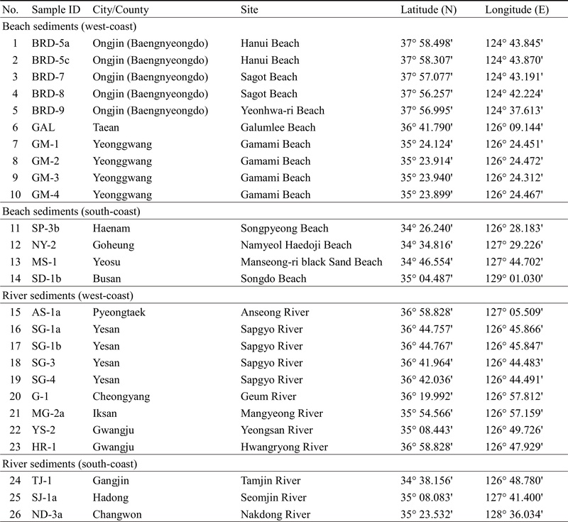
List of analyzed samples and their geographic locations.
해빈의 위치와 하천의 유입 경로에 따라 서해 해빈, 남해 해빈, 서부 하천 및 남부 하천 퇴적물로 분류하였다. 해빈과 하천의 퇴적환경 차이와 퇴적물 분포의 불균질성을 고려하여, 선행연구들을 참고하여 채취 방법을 설계하였다. 해빈 퇴적물의 경우 조수 또는 파도에 의한 일시적 피복 또는 침식 등의 단기적, 계절적 변동의 영향을 최소화하기 위해 표면으로부터 10 cm 이상의 깊이에서 퇴적물을 채취하였다(Ji et al., 1995; Kim, J.S. et al., 2010; Kim, S.Y. et al., 2012; So et al., 2012)(그림 2a). 하천 퇴적물은 위성지도를 참고하여 유수의 방향, 계절적 식생 및 퇴적물의 분포양상 차이, 접근성을 고려하여 하안 사주를 중심으로 채취 지점을 결정하였다. 각 채취 지점의 퇴적물의 공간적 불균질성을 고려하여 150 cm × 150 cm 격자망을 구성하였다. 구성된 구역내에서 9개의 등면적으로 구분한 후, 표층으로부터 10 cm 이상의 깊이에서 각 구역별로 약 60 g의 부분시료를 채취한 후 혼합하여 1개의 완전 시료를 분석시료로 사용했다(Ryu et al., 2015)(그림 2b). 하천 주변 접근성이 용이하지 않은 지역은 반 빈 채니기(Van Veen grab sampler)를 이용하여 시료를 채취하였다.

Photographs showing field sampling of beach sediments (a) and river sediments (b).
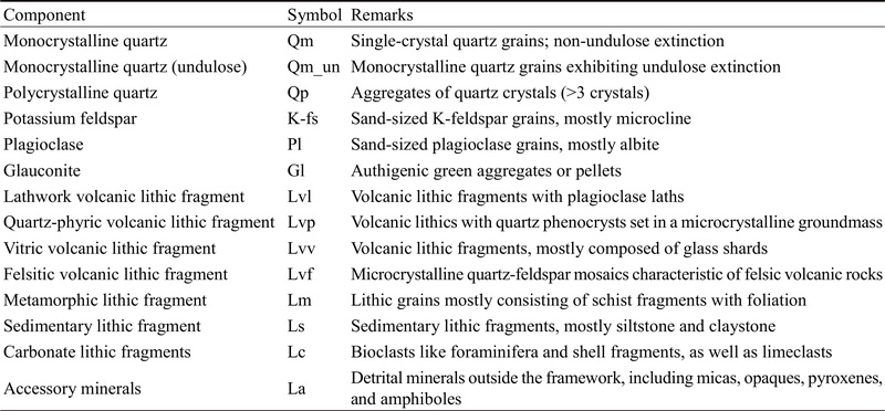
채취한 시료는 열풍건조기로 건조 후, 실체현미경(Zeiss Stemi 305)을 이용하여 간단한 광물조성 및 입도, 원마도 등의 퇴적물의 기본적 조직적 특성을 파악하였다. 건조 시료는 에폭시 레진과 혼합하여 24시간 이상 경화시킨 후에 30 μm 두께의 표준연마편을 제작하였다. 해빈 퇴적물 14개, 하성 퇴적물 12개 박편 내 골격입자를 대상으로 Gazzi-Dickinson의 점셈법(point counting methods)을 수행, 겉보기 조성을 파악하였다. 이후 Dickinson (1985)와 Garzanti (2019)의 광물 분류법을 참고하여 14개의 주요 구성성분으로 구분한 뒤, 편광현미경하에서 시료당 약 300개 이상의 점셈을 수행하였다(표 2; 그림 3).
Framework components and their descriptions used in petrographic modal analysis.

Representative thin section photograph (XPL) taken from samples of (a) Gamami beach (GM-1), (b) Manseong-ri beach (MS-1), (c) Sumjingang river (SJ-1a), and (d) Mangyeonggang river (MG-2a).
4. 결 과
4.1. 모래퇴적물 조직 특성
실체현미경 관찰을 통해 모래퇴적물의 기본적인 조직 특성을 파악하였다(표 3). 한반도 서부 해빈 시료의 입도는 세립사 내지 중립사로, 다른 지역의 퇴적물들에 비해 입도가 낮다. 예외적으로, 백령도 서부 해안의 BRD-9 시료는 입도가 세립사-조립사 범위로 나타나며 분급이 매우 불량하다. 서부 하성 퇴적물 시료의 입도는 조립사-세립자갈의 범위를 가져, 다른 지역의 퇴적물 시료에 비해 입도가 크고 분급이 불량하다. 남부 해빈 퇴적물 시료는 서부 해빈과는 달리 시료 채취 지점에 따라 조립사부터 세립자갈까지의 입도를 나타내, 입도와 분급의 지역적 편차가 크게 나타났다. 남부하성 퇴적물 또한 분급이 불량하며, 입도는 조립사-극조립사로 나타났다. 특징적으로 탐진강 시료(TJ-1)의 입도는 세립자갈 내지 자갈로 다른 시료들과 비교해 입도가 큰 양상을 보인다. 대부분의 연구 시료는 구형도가 낮고 원마도는 각형 내지 아각형으로 나타났으나, 대체로 해빈 모래 시료가 하성시료에 비해 분급이 양호하며 원마도 역시 높아 조직적으로 성숙한 경향을 나타낸다
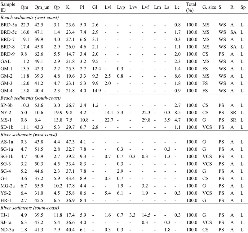
Petrographic point-counting results and textural properties of sediments. Abbreviations of point counting components are listed in table 2. Grain size classification follows the Wentworth scale (G: granule, VCS: very coarse sand; CS: coarse sand, MS: medium sand; FS: fine sand). S: sorting (WS: well sorted; PS: poorly sorted); R: roundness (SA: subangular; A: angular; SR: subrounded); Sp: sphericity (L: low).
4.2. 암석기재학적 특성
골격입자의 겉보기 조성 분석 결과는 표 3 및 그림 4에 제시하였다. 서부 해빈 퇴적물 내에서는 석영(Q)이 63.3±6.5% (n=10, 1 SD)로 가장 우세하게 나타났다. K-장석(K; 22.6±3.6%)과 사장석(Pl; 4.5±1.5%) 역시 모든 시료에서 관찰되며, 극히 일부 시료에서 화산암편(Lv: 0.6±1.1%)이 관찰되었다. 특징적으로, 모든 서부 해빈시료가 해록석 응집체(glauconite pellet)을 함유하며, 평균 6.9±4.8% 비율로 나타났다. 해록석은 하천퇴적물에서는 전혀 관찰되지 않았다.

Modal petrographic composition of the analyzed samples taken from (a) beach sediments and (b) river sediments.
서부 하성 시료는 서부 해빈 퇴적물과 유사하게 석영(53.5±9.1%; n=9, 1 SD), K-장석 (36.0±8.3%), 사장석(7.5±1.9%) 순으로 흔하게 나타났다. 석영과 K-장석이 비슷한 비율로 나타나거나 석영이 더 풍부하지만, 서부 해빈 퇴적물에 비해 K-장석이 더 높은 비율을 보였다. 안성천, 황룡강 시료(AS-1a, HR-1)를 제외한 모든 시료가 화산암편(2.8±4.3%)을 소량 포함하며, 영산강 시료(YS-2)는 다른 서부 하성 퇴적물들에 비해 화산암편의 함량이 풍부하였다(13.4%).
남부 해빈 퇴적물은 지역적 위치에 따라 구성성분에서 확연한 차이를 보였다. 송평 및 송도해수욕장 시료(SP-3b, SD-1b)의 광물성분은 석영(63.3±5.1%), K-장석(28.2±2.2%), 사장석(4.5±3.0%)이 주로 이 주요 성분이며, 해록석은 평균 2.0±1.1%의 함량을 보이고 암편(Lv, Lm, Ls)은 관찰되지 않았다. 그러나 남열해돋이 해변(NY-2)과 만성리 검은 모래 해변(MS-1)은 각각 화산암편이 41.6%, 52.5%로 가장 우세한 구성성분으로 나타났으며 모두 퇴적암편(2.1±2.5%)을 함유한다. 해당 시료들은 모든 시료 중 가장 낮은 석영(28.1±10.5%)과 K-장석(8.6±1.7%)의 함량을 보이며, 해록석은 관찰되지 않았다.
남부 하성 퇴적물은 석영(55.4±3.9%; n=3, 1 SD)이 가장 우세했으며, K-장석(31.5±12.3%), 사장석(5.3±1.2%), 화산암편(7.0±11.3%)이 모든 시료에서 나타났다. 서부 하성 퇴적물과 마찬가지로 해록석은 관찰되지 않았으며, 탐진강 시료는 화산암편 함량이 20.1%로 다른 하성 시료들에 비해 높은 함량 비율을 보였다.
5. 토 의
5.1. 하천 모래 퇴적물 조성
안성천(AS-1a), 삽교천(SG-1a, -1b, -3, 4), 금강(G-1) 시료는 공통적으로 석영 및 K-장석이 풍부한 특징을 나타낸다(그림 4). 이들 하천의 유역은 경기육괴 내 위치하여, 대부분의 퇴적물이 경기 편마암 복합체와 이를 관입한 쥐라기 대보화강암으로부터 기원한다. 경기육괴 지역을 구성하는 세부 암상은 매우 다양하여 특정한 광물이 지배적으로 나타난다고 여기기 어려우나, 화강암질 또는 화강섬록암질의 편마암 비중이 높은 국내 기반암의 특성상(Lee et al., 2003; Kee et al., 2019) 높은 함량의 석영과 알칼리장석이 나타나는 것으로 해석된다.
만경강 시료(MG-2a) 채취지점 인근은 지체구조적으로 옥천대로 간주되며 쥐라기 화강암이 널리 분포하나, 분석 대상 중 가장 높은 석영 함량(72.7%)을 나타낸다(그림 4). 이는 상류인 완주군 일대 옥천대에 분포하는 상부고생대 및 시대미상의 변성퇴적암류에 풍부한 사암 및 규암의 영향 등을 반영할 가능성이 있으나(e.g., Lim et al., 2005; Kee et al., 2019), 구배가 작은 김제평야의 지형 특성에 따라 화학적, 물리적으로 안정한 석영의 함량이 높아졌을 가능성도 존재한다.
영산강의 주요 지류인 황룡강 시료(HR-1)는 석영과 장석으로만 구성되어, 화산암편을 13.4% 함유한 영산강 시료(YS-2)와는 성분 차이를 보인다. 황룡강은 대부분의 유역이 선캄브리아시대 편마암 및 쥐라기 화강암으로 이루어진 반면, 다른 지류의 상류역에 해당하는 광주 동부에 중생대 화산암류가 분포하는 영향을 반영한다고 여겨진다. 유사하게, 탐진강(TJ-1) 시료 내 높은 화산암편 함량(20.1%)은 전남 강진, 장흥 일대에 넓게 분포하는 백악기 화산암류의 영향을 반영하여, 편마암 및 화강암이 지배적인 섬진강 유역의 시료(SJ-1a)와는 차이를 보인다.
낙동강은 태백산 인근에서 발원하여 남해에 이르는, 하천의 길이가 길고 유역면적이 넓은 대형 하천에 해당한다. 따라서 주요 기원지와 지질을 특정하기 어려우나, 유역의 상당부분이 지체구조적으로 영남육괴 및 경상분지에 해당하며, 경상누층군 및 불국사 화강암류로부터 많은 퇴적물이 기원했으리라 여겨진다(Kim, O.J., 1971; Chang, 1977; Choi, 1986; Kim, J.H., 1996). 경상누층군을 대상으로 한 암석기재학적 분석결과에 따르면 최하부 신동층군의 사암은 평균적으로 Q59F31R10(석영 59%, 장석 31%, 암편 10%)의 조성을 보이며(Lee and Lee, 2000; Lee et al., 2015), 하양층군에서 Q21-45F24-37R20-42로 나타나 석영의 기여도가 감소하고 장석 및 암편(주로 화산암편)의 함량이 증가한다(Koh and Lee, 1993; Oh et al., 1994; Lee and Lee, 2000; Lee and Kim, 2005; Lee et al., 2023). 이처럼 신동층군, 하양층군 내 화산암편이 풍부하고 최상위 유천층군이 대체로 화산암 및 화산쇄설암류로 이루어져 있음에도 낙동강 하류 퇴적물 시료(ND-3b)는 석영 및 장석의 기여가 지배적이며(Q 51.1%, F 46.5%), 화산암편과 퇴적암편의 함량은 각각 0.6%, 1.8%에 불과하다. 일반적으로 풍화 저항성이 낮은 화산암, 퇴적암 또는 이들의 퇴적암 내 암편이 한반도 서부의 노년기지형에서의 재퇴적과정에서 모래 크기 암편으로 재생산되기 어려우며, 이에 따라 퇴적암의 재퇴적과정은 보다 성숙한 조성의 퇴적물을 생성하기 때문으로 생각된다. 또한 유역내 널리 분포하는 불국사 관입암류로부터의 석영, 장석의 공급 역시 암편의 기여가 낮게 나타난 원인으로 볼 수 있다.
하천 퇴적물은 인위적인 공급 및 특별한 외부 공급원이 없는 한 해당 유역 내 노출된 기반암에서 직접적으로 기원하나, 연구 대상 하천 퇴적물의 골격 입자는 대체로 석영과 K-장석이 매우 우세하고 유역의 지질 특성에 따라 나타나는 기타 광물 또는 암편이 부수적으로 포함된다. 석영(Qt=Qm+Qm_un+Qp)-장석(F=K+P)-세립암편(L=Lv+Lm+Ls)의 상대적 조성을 나타내는 삼각도표(Q-F-L diagram)에 하천퇴적물의 조성을 도시하면(그림 5a), 이와 같은 조성의 유사성이 쉽게 인지된다. 이러한 유사성은 선캄브리아시대 편마암류와 및 쥐라기, 백악기의 화강암질 관입암이 우세한 지질, 그리고 이들로부터 퇴적물을 공급받은 퇴적분지의 영향을 나타낸다(Choi et al., 2016). 더불어, 풍화 저항성이 강한 광물들이 상대적으로 불안정한 광물 또는 암편에 비해 우세하게 잔류한 결과로도 해석된다. 이러한 풍화저항성의 차이는 조립사보다 세립사에서 더욱 두드러질 것으로 예상되며, 향후 단일시료에 대한 입도분리 후 암석기재학적 분석을 시도한다면 보다 상세한 고찰이 가능할 것으로 보인다.

Quartz-Feldspar-Lithic fragment (QFL) ternary diagrams showing the modal composition of (a) river sediments, (b) beach sediments, and (c) composite data. Quartz (Qt) represents the sum of Qm, Qm_un, and Qp.
5.2. 해빈 모래 퇴적물 조성
서해안 및 남해안의 해빈 모래 조성은 남열해돋이해수욕장(NY-2), 만성리검은모래해변(MS-1) 시료를 제외하면 지역에 따라 큰 차이를 보이지 않는다(그림 5b). 위 두 지역을 제외한 시료에서, 분지 내에서 형성되는 해록석과 생물 기원 탄산염 파편 외의 골격입자는 대부분 석영 및 K-장석으로 이루어지며 석영과 장석의 함량은 평균 63.3%, 23.6%이다. 또한 석영의 함량이 하천 퇴적물에 비해 높은 것이 특징적이다(그림 5c). 반면 남해 중부해역에 위치한 남열해돋이해수욕장과 만성리검은모래해변 시료는 화산암편의 평균 함량비가 47.1%로 매우 높고, 퇴적암편이 평균 2.1% 산출되어 QFL 다이어그램상 다른 퇴적물들과는 구분되는 영역에 도시된다. 이들 해빈 인근에는 대형 하천이 존재하지 않고, 인근 지질을 구성하는 백악기 화산암류에서 기원한 암편이 국지적으로 다량 공급된 것으로 해석할 수 있다.
이외의 해빈에서 하천 퇴적물에 비해 석영의 함량이 높게 나타나는 현상은 물리적, 화학적 저항성이 낮은 성분들이 운반 과정 및 퇴적 후 파랑의 작용으로 인해 선택적으로 제거된 결과로 일차적으로 해석될 수 있다. 실제로 해빈에 석영질의 모래가 집적되는 현상은 열대 및 온대 지역에서 널리 보고된 바 있다(Pittman, 1969; Savage and Potter, 1991; Mehring and McBride, 2007). 그러나 육지와 고립되어 있으며 주로 규암으로 이루어진 백령도의 해빈에도 장석이 유사한 비율로 산출되는 점으로 볼 때, 해빈 모래의 기원이 현생 퇴적 작용에 의해서만 설명되기는 어렵다.
황해는 빙하기 동안 해수면 하강으로 인해 노출되어 육지화되었다가 해빙기에 해침을 받아 현재와 같은 조건으로 변화하였는데(e.g., Kim and Kennett, 1998; Chough et al., 2004; Kwon, 2012), 이에 따라 여러 번의 해수면 하강기 동안 퇴적된, 모래질의 잔존 퇴적물(relict sediment)이 대륙붕내 널리 분포한다(Lee and Chough, 1989; Choi and Park, 1993). 서해 및 남해 해빈 퇴적물의 조성은 기존 보고된 황해 대륙붕의 잔존퇴적물과 큰 차이를 보이지 않는다. Park et al. (1994, 1999)은 한반도 인근해 대륙붕 표층퇴적물 내석영과 장석이 각각 65-70%, 15-20%의 함량비를 보이며, (석영+장석)/암편의 비율로 계산되는 퇴적물 성숙도 지수(sediment maturity index)가 일반적인 연안 해양환경 퇴적물의 성숙도 지수인 2.0-3.0을 넘는 5.0 이상임을 보고하였다. 이러한 조성은 황해와 동중국해의 외대륙붕 모래질 퇴적물과도 유사하다. 서해 및 남해로 유입되는 하천 퇴적물의 광물조성이 서로 유사함을 고려할 때, 현재 대륙으로부터 고립되어 있는 백령도 등의 도서지역도 과거 해수면 하강기 동안에는 육지와 연결되어 있었으므로 다른 해빈 퇴적물과 유사한 조성을 나타내는 것으로 해석된다.
다만 최근 주요 해수욕장의 모래 유실이 심각하여 해안정비사업 및 이에 따른 양빈을 시행하는 경우가 많아, 해빈사의 조성이 자연적 요인만을 반영한다고 보기 어렵다. 이러한 이유로 본 연구에서는 비교적 관광객이 적고 해안정비사업의 기록이 확인되지 않은 해수욕장 또는 해빈을 중심으로 분석을 시도하였지만, 송도해수욕장 등 관광객의 방문이 많은 대규모 해수욕장은 양빈된 모래를 상당량 포함할 것으로 여겨진다. 이러한 변수는 정량화하기 어려우나 파랑의 영향이 크고 해빈의 유실이 진행되고 있는 남해, 동해안 해수욕장에서는 기원지 해석의 어려움으로 작용한다.
5.3. 해록석
해록석(glauconite 또는 glaucony)는 Fe와 Mg를 포함하는 수화 알루미노실리케이트계 운모 광물로, 이 광물을 포함한 녹색 응집체(aggregate) 또는 펠릿(pellet)을 통칭하기도 한다. 현생 해양환경에서의 해록석은 수심 50 m 이상의 저에너지 환경, 특히 200-300 m 깊이의 외대륙붕 환경에서 자생적으로 형성된다(Odin and Matter, 1981; Logvinenko, 1982; Chafetz and Reid, 2000). 특히 퇴적물 공급이 제한적인 해침 조건에서 해수와 퇴적물이 오랜 시간 접촉하여 만들어지며, 50 m 이하의 수심 조건에서는 형성되지 않는다(Bathurst, 1975).
본 연구 대상 해빈의 모래퇴적물은 남열해돋이 해수욕장(NY-2)과 만성리 검은모래해변(MS-1)을 제외하고 모두 일정량의 해록석을 함유하였다. 한반도 인근해 대륙붕 퇴적물 내 해록석 분포는 Park et al. (1994), Lee et al. (1997), Lim et al. (2000) 등에 의해 보고된 바 있으며, 이들은 해록석을 먼 과거 고해수면기에 형성되었다가 지난 최대 빙하기(LGM) 이후 또는 초기 현세동안 해수면이 상승하는 과정에서 재동되어 집적된 해침성 사질 퇴적체인 잔존퇴적물로 해석하였다. 이는 현재의 황해 대륙붕 저서환경은 해록석 형성에 유리하지 않고, 황해는 여러 번의 해수면변동에 따른 해침 및 해퇴의 영향을 겪어 왔으며(e.g., Wang et al., 2021), 해록석 형태나 성분이 성숙하며, 모래질 잔존퇴적물이 표층에 분포하는 해역에서 흔히 산출되기 때문이다(Park et al., 1994; Lim et al., 2000). 강 하구 퇴적물에서 해록석이 관찰되지 않은 점은 해록석의 외부 유입(allochthonous) 가능성이 낮다는 기존 연구 결과를 지지하며, 해수면 하강기에 노출된 대륙붕에 존재하던 해록석이 해수면 상승 및 해침 과정에서 파랑 및 연안류에 의해 해빈으로 운반되었음을 시사한다.
연구 지역 내 해록석 함량은 서해안, 특히 태안의 갈음이 해수욕장(GAL)과 영광의 가마미 해수욕장(GM-1, 2, 3, 4)에서 가장 높게 나타났다. 이는 지형 구배가 완만하고 조간대가 넓게 분포하며, 조석의 영향이 강하게 작용하는 서해안 특유의 지형적·해양학적 조건과 더불어 파랑의 영향을 크게 받는 해빈 환경이 갖춰져 있어, 해수면 상승에 따라 해빈과 해안사주가 해안선과 함께 육지 쪽으로 후퇴하는 해안사면 후퇴(shoreface retreat)가 효과적으로 발생했음을 시사한다(그림 6) (Yang et al., 2006; Lee and Yi, 2017; Lee et al., 2020). 반면 백령도 해빈과 송평, 송도해수욕장에서는 해록석 함량이 최대 3.1%로 비교적 낮고 남해안의 남열 해돋이 해수욕장과 만성리 검은모래해변에서는 전혀 산출되지 않았다. 이러한 차이는 좁은 대륙붕과 상대적으로 급한 지형 구배로 인해 해안사면 후퇴가 제한되었거나, 낙동강과 같은 대규모 하천이 인접하여 쇄설성 퇴적물 유입이 많아 해록석의 상대적 비중이 낮아졌기 때문으로 해석할 수 있다. 특히 남해안은 복잡한 다도해 지형과 해협의 분포로 인해 파랑과 조류의 흐름이 매우 복잡하며, 반폐쇄적인 해양 환경이 흔히 나타난다. 또한 남해 대륙붕에 본래 해록석이 거의 산출되지 않는 점을 고려할 때(Lim et al., 2000), 대륙붕으로부터의 유입원은 없었다고 볼 수 있다.

Schematic diagrams illustrating shoreline evolution in response to sea-level changes (modified and regenerated from Waters, 1992). (a) Sea-level lowstand with a subaerially exposed continental shelf. (b) Early transgressive phase showing a barrier-beach system advancing toward the shelf break. (c-d) Shoreline overstepping or landward retreat, depending on the balance between accommodation space and sediment supply.
6. 고찰 및 결론
본 연구는 한반도 서·남해 연안의 해빈 및 하천 퇴적물의 암석기재학적 특성을 분석함으로써, 현대 퇴적환경에 기반한 기원지 해석과 그 지질학적 함의를 도출하였다. 서해 및 남해로 유입되는 하천의 모래 입자 조성은 석영 및 K-장석이 지배적으로 나타나며, 지역 지질에 따른 조성 차이는 화산암편의 기여도 외에는 뚜렷하게 나타나지 않는다. 이는 서로 다른 기원암으로부터 유래한 동일 광물이 식별되기 어렵고, 특정 광물 및 구성성분이 차별적으로 풍화되거나 제거되며, 이들이 윤회하며 혼합, 균질화되기 때문으로 해석된다. 따라서 암석기재학적 특성에 기반한 하천 퇴적물의 기원지 정보는 이러한 과정에 의해 다소 단순화될 우려가 있다. 이러한 한계는 풍화저항성이 높은 쇄설성 저어콘을 이용한 지질연대학적 연구(e.g., Choi et al., 2016), 지화학 조성을 통한 세립퇴적물의 기원지 해석(e.g., Joo, 2024) 등을 병행하여 보완될 수 있으리라 보인다.
서해안 및 남해안 해빈 모래는 전반적으로 석영과 K-장석이 우세한 조성을 보이며, 이는 한반도의 주요 하천을 통해 공급된 모래질 퇴적물이 풍화 과정에서 불안정한 광물이 제거된 결과로 해석할 수 있다. 그러나 서해안 일대에서 흔히 나타나는 해록석의 존재, 황해 내·외대륙붕 퇴적물과의 조성적 유사성, 그리고 백령도 등 고립된 지역에서도 유사한 광물 조성이 나타나는 점 등으로 보아 황해 대륙붕으로부터 기인한 퇴적물이 한반도 서·남해안의 해빈에 상당량 유입되었다고 여겨진다. 사질퇴적물은 현재와 같은 고해면기에는 대체로 하구 주변 및 인근 해빈에 퇴적되나, 신생대 제4기 동안의 해수면 변동에 따른 하구와 해안선의 전진과 후퇴에 의해 황해 대륙붕 곳곳에 널리 분포한다(e.g., Jin and Chough, 1998; Jung et al., 1998; Lim et al., 2015; Cummings et al., 2016). 이후 상승기에 해안선이 현재 황해의 연안지형을 따라 육지 방향으로 후퇴하면서 대륙붕 퇴적물이 재동되어 현재의 해빈 퇴적물로 기여했을 것으로 보인다. 이러한 현상은 특히 신생대 제4기 해수면의 상승 및 하강에 의한 영향이 크게 나타난 대륙붕 환경에서의 기원지 해석에 복잡성으로 작용할 수 있으며, 다중 지시자를 활용한 종합적 분석의 필요성을 시사한다.
Acknowledgments
연구 아이디어를 제공해 주신 이용일 교수님, 시료획득과 박편제작에 도움을 준 전북대학교 퇴적논문반 구성원, 논문에 건설적인 의견을 주신 편집위원과 심사위원께 감사드립니다. 본 연구는 과학기술정보통신부 재원으로 한국연구재단의 지원을 받아 수행되었습니다(RS-2025-00563306).
References
-
Alexander, C.R., Demaster, D.J. and Nittrouer, C.A., 1991, Sediment accumulation in a modern epicontinental-shelf setting: The Yellow Sea. Marine Geology, 98, 51-72.
[https://doi.org/10.1016/0025-3227(91)90035-3]

- Bathurst, R.G.C., 1975, Carbonate Sediments and their Diagenesis (2nd ed.), Elsevier, Amsterdam.
-
Chafetz, H.S. and Reid, A., 2000, Syndepositional shallow-water precipitation of glauconitic minerals. Sedimentary Geology, 136, 29-42.
[https://doi.org/10.1016/S0037-0738(00)00082-8]
- Chang, K.-H., 1977, Late Mesozoic Stratigraphy, Sedimentation and Tectonics of Southeastern Korea. Journal of the Geological Society of Korea, 13, 76-90 (in Korean).
-
Choi, H.I., 1986, Sedimentation and evolution of the Cretaceous Gyeongsang Basin, southeastern Korea. Journal of the Geological Society, 143, 29-40.
[https://doi.org/10.1144/gsjgs.143.1.0029]
- Choi, J.Y. and Park, Y.A., 1993, Distributions and textural characters of the bottom sediments on the continental shelves, Korea. Journal of the Oceanological Society of Korea, 28, 259-271 (in Korean with English abstract).
-
Choi, T., Lee, Y.I. and Orihashi, Y., 2016, Crustal growth history of the Korean Peninsula: Constraints from detrital zircon ages in modern river sediments. Geoscience Frontiers, 7, 707-714.
[https://doi.org/10.1016/j.gsf.2016.05.003]
- Chough, S.K., 1983, Marine geology of Korea sea. Int. Hum. Resour. Univ., 52 p.
-
Chough, S.K., Kwon, S.-T., Ree, J.-H. and Choi, D.K., 2000, Tectonic and sedimentary evolution of the Korean peninsula: a review and new view. Earth-Science Reviews, 52, 175-235.
[https://doi.org/10.1016/S0012-8252(00)00029-5]
-
Chough, S.K., Lee, H.J., Chun, S.S. and Shinn, Y.J., 2004, Depositional processes of late Quaternary sediments in the Yellow Sea: a review. Geosciences Journal, 8, 211-264.
[https://doi.org/10.1007/BF02910197]
-
Chough, S.K., Lee, H.J. and Han, S.J., 1991, Sedimentological and geotechnical properties of fine-grained sediments in part of the South Sea, Korea. Continental Shelf Research, 11, 183-195.
[https://doi.org/10.1016/0278-4343(91)90061-A]
-
Cummings, D., Dalrymple, R., Choi, K. and Jin, J., 2016, The Tide-dominated Han River delta, Korea: Geomorphology, sedimentology, and stratigraphic architecture. Elsevier, Amsterdam, 382 p.
[https://doi.org/10.1016/B978-0-12-800768-6.00004-3]
-
Dickinson, W.R., 1985, Interpreting provenance relations from detrital modes of sandstones. In: Zuffa, G.G. (ed.), Provenance of Arenites. NATO ASI Series, vol. 148. Springer, Dordrecht, 333-361.
[https://doi.org/10.1007/978-94-017-2809-6_15]
-
Dong, L.X., Guan, W.B., Chen, Q., Li, X.H., Liu, X.H. and Zeng, X.M., 2011, Sediment transport in the Yellow Sea and East China Sea. Estuarine, Coastal and Shelf Sciences, 93, 248-258.
[https://doi.org/10.1016/j.ecss.2011.04.003]
-
Emery, K.O., 1968, Relict sediments on continental shelves of world. AAPG Bulletin, 52, 445-464.
[https://doi.org/10.1306/5D25C2E7-16C1-11D7-8645000102C1865D]
-
Folk, R.L., 1954, The distinction between grain size and mineral composition in sedimentary rock nomenclature. Journal of Geology, 62, 344-359.
[https://doi.org/10.1086/626171]
-
Garzanti, E., 2019, Petrographic classification of sand and sandstone. Earth-Science Reviews, 192, 545-563.
[https://doi.org/10.1016/j.earscirev.2018.12.014]
-
Hu, D.X., 1984, Upwelling and sedimentation dynamics I. The role of upwelling in sedimentation in the Huanghe Sea and East China Sea-a description of general features. Chinese Journal of Oceanological Limnology, 2, 12-19.
[https://doi.org/10.1007/BF02888388]
- Ji, O.M. and Woo, K.S., 1995, Compositional variations of the beach sediments in Cheju Island. The Journal of the Korean Society of Oceanography, 30, 480-492 (in Korean with English abstract).
-
Jin, J.H. and Chough, S.K., 1998, Partitioning of transgressive deposits in the southeastern Yellow Sea: a sequence stratigraphic interpretation. Marine Geology, 149, 79-92.
[https://doi.org/10.1016/S0025-3227(98)00023-1]
-
Joo, Y.J., 2024, Geochemistry of surface sediments near the Nakdong River Estuary: Chemical weathering and source rock composition. Journal of the Korean Earth Science Society, 45, 449-455 (in Korean with English abstract).
[https://doi.org/10.5467/JKESS.2024.45.5.449]
-
Jung, H.-S., Lim, D., Jeong, D.-H., Xu, Z. and Li, T., 2016, Discrimination of sediment provenance in the Yellow Sea: Secondary grain-size effect and REE proxy. Journal of Asian Earth Sciences, 123, 78-84.
[https://doi.org/10.1016/j.jseaes.2016.03.020]
-
Jung, W.Y., Suk, B.C., Min, G.H. and Lee, Y.K., 1998, Sedimentary structure and origin of a mud-cored pseudotidal sand ridge, eastern Yellow Sea, Korea. Marine Geology, 151, 73-88.
[https://doi.org/10.1016/S0025-3227(98)00058-9]
- Kee, W.-S., Kim, S.W., Hong, P.S., Lee, B.C., Cho, D.R., Byun, U.H., Ko, K., Kwon, C.W., Kim, H.C., Jang, Y., Song, K.Y., Koh, H.J. and Lee, H.J., 2019, 1:1,000,000 Geologic Map of Korea. Korea Institute of Geoscience and Mineral Resources (in Korean with English abstract).
-
Kim, J.H., 1996, Mesozoic tectonics in Korea. Journal of Southeast Asian Earth Sciences, 13, 251-265.
[https://doi.org/10.1016/0743-9547(96)00032-3]
-
Kim, J.M. and Kennett, J.P., 1998, Paleoenvironmental changes associated with the Holocene marine transgression, Yellow Sea (Hwanghae). Marine Micropaleontology, 34, 71-89.
[https://doi.org/10.1016/S0377-8398(98)00004-8]
- Kim, J.-S., Park, N.-W. and Jang, D.-H., 2010, Characteristics variation of the sedimentary environment in winter season around the Baramarae Beach of Anmyeondo using surface sediment analysis. Journal of the Korean Geomorphological Association, 17, 15-27 (in Korean with English abstract).
- Kim, O.J., 1971, Study on the Intrusion Epochs of Younger Granites and their Bearing to Orogenies in South Korea. Economic and Environmental Geology, 4, 1-9 (in Korean with English abstract).
-
Kim, S.Y., Jeong, J.B. and Lee, B.K., 2012, Seasonal variation of surface sediment distribution and transport pattern offshore Haeundae Beach Area. The Sea: Journal of the Korean Society of Oceanography, 17, 16-24 (in Korean with English abstract).
[https://doi.org/10.7850/jkso.2012.17.1.016]
-
Klein, G.D., Park, Y.A., Chang, J.H. and Kim, C.S., 1982, Sedimentology of a subtidal, tide-dominated sand body in the Yellow Sea, southwest Korea. Marine Geology, 50, 221-240.
[https://doi.org/10.1016/0025-3227(82)90140-2]
- Koh, I.S. and Lee, Y.T., 1993, Sedimentary petrology of Cretaceous sandstones in the southern margin of Euiseong Subbasin. Journal of the Geological Society of Korea, 29, 225-245 (in Korean with English abstract).
- Kwon, J.T., Chi, J.M. and Jang, Y.H., 1999, Geochemical relationship between shore sediments and geology in Byeonsan Area, west coast of Korea. Journal of the Korean Society of Mineral and Energy Resources Engineers, 36, 42-66.
-
Kwon, Y.K., 2012, Late Quaternary Sequence Stratigraphy in Kyeonggi Bay, Mid-eastern Yellow Sea. Journal of Korean Earth Science Society, 33, 242-258.
[https://doi.org/10.5467/JKESS.2012.33.3.242]
-
Lee, B.Y., Oh, C.W. and Yun, H., 2021, Review on the Neoproterozoic igneous activity in the Korean Peninsula and the Neoproterozoic correlation between the Korean Peninsula and China. Journal of the Geological Society of Korea, 57, 467-493 (in Korean with English abstract).
[https://doi.org/10.14770/jgsk.2021.57.4.467]
- Lee, C.H., Lee, S.R., Lee, C.W. and Choi, S.W., 1997, Geochemical variation of authigenic glauconite from continental shelf of the Yellow Sea, off SW Korea. Economic and Environmental Geology, 30, 303-312 (in Korean with English abstract).
-
Lee, H.J. and Chough, S.K., 1989, Sediment distribution, dispersal and budget in the Yellow Sea. Marine Geology, 87, 195-205.
[https://doi.org/10.1016/0025-3227(89)90061-3]
-
Lee, H.J. and Chu, Y.S., 2001, Origin of inner-shelf mud deposit in the southeastern Yellow Sea: Huksan Mud Belt. Journal of Sedimentary Research, 71, 144-154.
[https://doi.org/10.1306/040700710144]
-
Lee, H.J., Jeon, C.K. and Lim, H.S., 2020, Transgressive shelf sands around the Korean Peninsula: a brief review. Ocean Science Journal, 55, 465-475.
[https://doi.org/10.1007/s12601-020-0035-5]
-
Lee, H.J. and Yi, H.I., 2017, Seabed gradient controlling onshore transport rates of surf sand during beach retreat by sea level rise. Ocean Science Journal, 53, 133-142.
[https://doi.org/10.1007/s12601-017-0056-x]
-
Lee, J.I. and Lee, Y.I., 2000, Provenance of the Lower Cretaceous Hayang Group, Gyeongsang Basin, southeastern Korea: implications for continental-arc volcanism. Journal of Sedimentary Research, 70, 151-158.
[https://doi.org/10.1306/2DC40906-0E47-11D7-8643000102C1865D]
-
Lee, S.R., Cho, M., Hwang, J.H., Lee, B.-J., Kim, Y.-B. and Kim, J.C., 2003, Crustal evolution of the Gyeonggi massif, South Korea: Nd isotopic evidence and implications for continental growths of East Asia. Precambrian Research, 121, 25-34.
[https://doi.org/10.1016/S0301-9268(02)00196-1]
-
Lee, Y.I. and Kim, J.Y., 2005, Provenance of the Hayang Group (Early Cretaceous) in the Yeongyang Subbasin, SE Korea and its bearing on the cretaceous palaeogeography of SW Japan. Palaeogeography, Palaeoclimatology, Palaeoecology, 228, 278-295.
[https://doi.org/10.1016/j.palaeo.2005.06.017]
-
Lee, Y.I., Lee, J.I. and Choi, Y.S., 2023, Provenance analysis of the Cretaceous Gyeongsang Basin, SE Korea: A synthesis and tectonic implications for active continental margin in East Asia. Earth-Science Reviews, 238, 104334.
[https://doi.org/10.1016/j.earscirev.2023.104334]
-
Lee, Y.I., Yi, J. and Choi, T., 2015, Provenance Analysis of Lower Cretaceous Sindong Group Sandstones in the Gyeongsang Basin, Korea, Using Integrated Petrography, Quartz Sem-Cathodoluminescence, and Zircon Zr/Hf Analysis. Journal of Sedimentary Research, 85, 529-543.
[https://doi.org/10.2110/jsr.2015.36]
- Lim, D.I., Park, Y.A., Cho, J.W. and Choi, J.Y., 1999, The occurrence of glauconite grains on the continental shelves off the Korean Peninsula: Distribution, Morphology and Origin. The Journal of the Korean Society of Oceanography, 34, 113-121.
-
Lim, D.I., Park, Y.A., Choi, J.Y., Cho, J.W. and Khim, B.K., 2000, Glauconite grains in continental shelf sediments around the Korean Peninsula and their depositional implications. Geo-Marine Letters, 20, 80-86.
[https://doi.org/10.1007/s003670000045]
-
Lim, D., Xu, Z.K., Choi, J.Y., Li, T.G. and Kim, S.Y., 2015, Holocene changes in detrital sediment supply to the eastern part of the central Yellow Sea and their forcing mechanisms. Journal of Asian Earth Sciences, 105, 18-31.
[https://doi.org/10.1016/j.jseaes.2015.03.032]
- Lim, S.-B., Chun, H.Y., Kim, Y.B., Kim, B.C. and Cho, D.-L., 2005, Geologic ages, stratigraphy and geological structures of the metasedimentary strata in Bibong-Yeonmu area, NW Okcheon belt, Korea. Journal of the Geological Society of Korea, 41, 335-368 (in Korean with English abstract).
-
Logvinenko, N.V., 1982, Origin of glauconite in the recent bottom sediments of the ocean. Sedimentary Geology, 31, 43-48.
[https://doi.org/10.1016/0037-0738(82)90006-9]
-
Mehring, J.L. and McBride, E.F., 2007, Origin of modern quartzarenite beach sands in a temperate climate, Florida and Alabama, USA. Sedimentary Geology, 201, 432-445.
[https://doi.org/10.1016/j.sedgeo.2007.07.010]
-
Milliman, J.D. and Meade, R.H., 1983, World-wide delivery of river sediment to the oceans. The Journal of Geology, 91, 1-21.
[https://doi.org/10.1086/628741]
- Moon, D.H., Yi, H.I., Shin, K.H., Do, J.Y. and Cho, H.G., 2009, Mineral distribution of the southeastern Yellow Sea and southern sea of Korea using quantitative XRD analysis. Journal of the Mineralogical Society of Korea, 22, 49-61 (in Korean with English abstract).
-
Off, T., 1963, Rythmic Linear Sand Bodies Caused by Tidal Currents. AAPG Bulletin, 47, 324-341.
[https://doi.org/10.1306/BC743989-16BE-11D7-8645000102C1865D]
-
Oh, C.W. and Kim, Y.H., 2021, The geological correlation between the Korean Peninsula and China from Paleoproterozoic to Triassic and the comparative evaluation among the Permo-Triassic collision models in the Northeast Asia. Journal of the Geological Society of Korea, 57, 369-412 (in Korean with English abstract).
[https://doi.org/10.14770/jgsk.2021.57.4.369]
- Oh, J.H., Kwak, Y.H., Son, J.D., Cheong, T.J., Ryu, B.J., Son, B.K., Lee, Y.J., Kim, H.J. and Hwang, I.G., 1994, Petroliferous basin analysis in Euiseong area (II). Assessment of Petroleum Resources (1), Korea Institute of Geology Mining and Materials, Daejeon, 402 p (in Korean).
-
Odin, G.S. and Matter, A., 1981, De glauconiarum origine. Sedimentology, 28, 611-641.
[https://doi.org/10.1111/j.1365-3091.1981.tb01925.x]
- Oh, J.-K. and Kum, B.-C., 2001, Depositional Environments and Characteristics of Surface Sediments in the Nearshore and Offshore off the Mid-Western Coast of the Korean Peninsula. Journal of the Korean Earth Science Society, 22, 377-387 (in Korean with English abstract).
-
Park, S.C., Lee, H.H., Han, H.S., Lee, G.H., Kim, D.C. and Yoo, D.G., 2000, Evolution of late Quaternary mud deposits and recent sediment budget in the southeastern Yellow Sea. Marine Geology, 170, 271-288.
[https://doi.org/10.1016/S0025-3227(00)00099-2]
- Park, Y.A. and Choi, J.Y., 1986, Factor Analysis of the continental shelf sediments off the Southeast Coast of Korea and its implication to the depositional environments. Journal of the Oceanological Society of Korea, 21, 34-35.
- Park, Y.A., Choi, J.Y., Lee, C.B., Kim, D.C. and Choi, K.W., 1994, Sediment distributions and depositional processes on the inner continental shelf off the West Coast (Middle Part) of Korea. Journal of the Korean Society of Oceanography, 29, 357-365 (in Korean with English abstract).
- Park, Y.A., Choi, J.Y., Lim, D.I. and Hwang, N.S., 1999, Mineral compositions and textural characters of the bottom sandy sediments off Taean Peninsula, West Sea of Korea. The Korean Journal of Quaternary Research, 13, 99-106 (in Korean with English abstract).
-
Park, Y.A., Kim, S.C. and Choi, J.H., 1986, The distribution and transportation of fine-grained sediments on the inner continental shelf off the Keum river estuary, Korea. Continental Shelf Research, 5, 499-519.
[https://doi.org/10.1016/0278-4343(86)90073-7]
-
Pittman, E.D., 1969, Destruction of plagioclase twins by stream transport. Journal of Sedimentary Petrology, 39, 1432-1437.
[https://doi.org/10.1306/74D71E4C-2B21-11D7-8648000102C1865D]
-
Ren, M.-E. and Shi, Y.-L., 1986, Sediment discharge of the Yellow River (China) and its effect on the sedimentation of the Bohai and the Yellow Sea. Continental Shelf Research, 6, 785-810.
[https://doi.org/10.1016/0278-4343(86)90037-3]
- Ryu, J.Y., Youn, S.-T., Koh, Y.-K. and Oh, K.-H., 2015, The depositional environments and roundness of surface sediments in mid to downstream of the Seomjin River. Journal of the Koran Geomorphological Association, 22, 63-74 (in Korean with English abstract).
-
Savage, K.M. and Potter, P.E., 1991, Petrology of modern sands of the rios Guaviare and Inirida, southern Colombia; tropical climate and sand composition. Journal of Geology, 99, 289-298.
[https://doi.org/10.1086/629489]
- Schubel, J.R., Shen, H.-T. and Park, M.J., 1984, A comparison of some characteristic sedimentation processes of estuaries entering the Yellow Sea. In: Y.A. Park, O.H. Pilkey and S.W. Kim (Eds), Marine Geology and Physical Processes of the Yellow Sea. Korea Institute of Energy Resources, Seoul, p. 286-308.
-
Schubel, J.R., Shen, H.T. and Park, M.J., 1986, Comparative analysis of estuaries bordering the Yellow Sea. In: Wolfe, D.A. (Ed.), Estuarine Variability. Academic Press, London, p. 43-62.
[https://doi.org/10.1016/B978-0-12-761890-6.50008-3]
-
So, K.-S., Ryang, W.-H., Choi, S.-L. and Kwon, Y.-K., 2012, Seasonal variation of surface sediments in the Kwangseungri Beach, Gochanggun, Korea. Journal of the Korean Earth Science Society, 33, 497-509 (in Korean with English abstract).
[https://doi.org/10.5467/JKESS.2012.33.6.497]
- Waters, M.R., 1992, Principles of geoarchaeology: A North American perspective. Tucson: University of Arizona Press, 398 p.
-
Wang, L., Li, G., Liu, J., Mei, X. and Zhang, Y., 2021, Astronomical dating of Quaternary strata in the South Yellow Sea and its indication for paleoclimatic evolution. Marine Geology, 439, 106557.
[https://doi.org/10.1016/j.margeo.2021.106557]
-
Yang, B.C., Dalrymple, R.W., Chun, S.S. and Lee, H.J., 2006, Transgressive sedimentation and stratigraphic evolution of a wave-dominated macrotidal coast, western Korea. Marine Geology, 235, 35-48.
[https://doi.org/10.1016/j.margeo.2006.10.003]
-
Zheng, Q.A. and Klemas, V., 1982, Determination of winter temperature patterns, fronts, and surface currents in the Yellow Sea and East China Sea from satellite imagery. Remote Sensing Environment, 12, 201-208.
[https://doi.org/10.1016/0034-4257(82)90053-0]